Geographic Region: FRANCE
Feature: PARIS AREA
|
Geographic Region: FRANCE Feature: PARIS AREA |
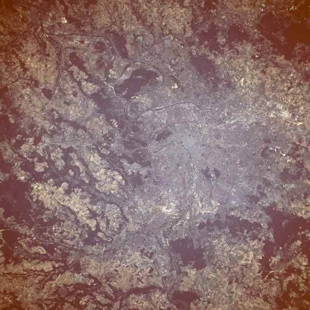 |
| STS047-094-010 Paris, France September 1992 Unlike much younger North American cities, Paris does not have a neat and orderly "checkerboard" street pattern. Furthermore, the large, old trees that line the streets of metropolitan Paris obscure what pattern there is. Most of the population of France is evenly distributed throughout the country; the only exception of concentrated urban population is Paris. With a population of approximately 10 million people, Paris is without rival in France. The Seine River and the two large airports (Charles de Gaulle northeast of the central city and Orly to the south) are the major identifiable features in this near-vertical photograph. The dark areas on the photograph outside the metropolitan areas are forests, and the dark (vegetated) areas in the city are parks. Prominent are the Bois de Boulogne in a downstream loop of the Seine and the Bois de Vincennes near an upstream loop. The original city of Paris was founded in pre-Roman times on an island in the Seine River. Paris is positioned geographically in the Paris Basin, relatively flat terrain that becomes gently rolling hills. The city lies in a large, prosperous agricultural region that has enhanced the development of Paris. |
| Images: | All Available Images Low-Resolution 170k |
|
| Mission: | STS047 |
|
| Roll - Frame: | 94 - 10 |
|
| Geographical Name: | FRANCE |
|
| Features: | PARIS AREA |
|
| Center Lat x Lon: | 49.0N x 2.0E |
|
| Film Exposure: | N | N=Normal exposure, U=Under exposed, O=Over exposed, F=out of Focus |
| Percentage of Cloud Cover-CLDP: | 0 |
|
| Camera:: | HB |
|
| Camera Tilt: | 26 | LO=Low Oblique, HO=High Oblique, NV=Near Vertical |
| Camera Focal Length: | 250 |
|
| Nadir to Photo Center Direction: | NW | The direction from the nadir to the center point, N=North, S=South, E=East, W=West |
| Stereo?: | Y | Y=Yes there is an adjacent picture of the same area, N=No there isn't |
| Orbit Number: | 49 |
|
| Date: | 19920915 | YYYYMMDD |
| Time: | 151606 | GMT HHMMSS |
| Nadir Lat: | 48.3N |
Latitude of suborbital point of spacecraft |
| Nadir Lon: | 3.2E |
Longitude of suborbital point of spacecraft |
| Sun Azimuth: | 244 | Clockwise angle in degrees from north to the sun measured at the nadir point |
| Space Craft Altitude: | 170 | nautical miles |
| Sun Elevation: | 27 | Angle in degrees between the horizon and the sun, measured at the nadir point |
| Land Views: | PLAIN |
|
| Water Views: | RIVER |
|
| Atmosphere Views: | |
|
| Man Made Views: | AGRICULTURE, URBAN AREA |
|
| City Views: | PARIS |
|
Photo is not associated with any sequences | ||
| NASA Home Page |
JSC Home Page |
JSC Digital Image Collection |
Earth Science & Remote Sensing |
|
This service is provided by the International Space Station program and the JSC Earth Science & Remote Sensing Unit, ARES Division, Exploration Integration Science Directorate.

|