Geographic Region: EGYPT
Feature: ASWAN DAM, LAKE NASSER
|
Geographic Region: EGYPT Feature: ASWAN DAM, LAKE NASSER |
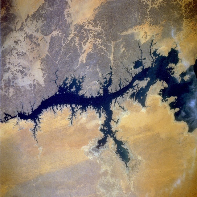 |
| STS046-075-018 Nile River and Aswan Dam, Egypt August 1992 The Nile River is the longest river in the world and unquestionably the "life blood" of Egypt. Throughout Egypt's history the Nile River has provided water for drinking, irrigation, and replenishment of fertile soils. About 95 percent of Egypt's population lives within 12 miles (20 kilometers) of the river's banks or on its delta. This segment of the Nile River has been modified by the construction of the Aswan High Dam. The dam is barely visible toward the northern edge of the photograph. This project was begun in 1958, and the dam was dedicated in 1971. The 365-foot-high (110-meter-high) dam created Lake Nasser, one of the world's largest artificial lakes. A series of photographs of Lake Nasser, taken in different seasons and years, is useful in mapping the seasonally influenced fluctuating water levels in the lake. Water levels are normally lowest during April and May; then during the summer months the water level rises. The dam has dramatically (1) changed how Egyptians irrigate their fields, (2) increased oil-poor Egypt's hydroelectric power generation, and (3) curtailed flood control problems. The inundated area created behind the Aswan High Dam extends into a small area of north-central Sudan. The Aswan High Dam, 2.5 miles across and 364 feet high, (24.0N, 33.0E) completed in 1971, was constructed to supply cheap hydroelectric power to both Egypt and Sudan by impounding, controling and regulating the flood waters of the Nile River in Lake Nasser, the world's second largest artifical lake. The lake extends over 500 miles in length, covers an area of some 2,000 square miles and is as much as 350 feet deep at the face of the dam. |
| Images: | All Available Images Low-Resolution 148k |
|
| Mission: | STS046 |
|
| Roll - Frame: | 75 - 18 |
|
| Geographical Name: | EGYPT |
|
| Features: | ASWAN DAM, LAKE NASSER |
|
| Center Lat x Lon: | 24.0N x 33.0E |
|
| Film Exposure: | N | N=Normal exposure, U=Under exposed, O=Over exposed, F=out of Focus |
| Percentage of Cloud Cover-CLDP: | 0 |
|
| Camera:: | HB |
|
| Camera Tilt: | 42 | LO=Low Oblique, HO=High Oblique, NV=Near Vertical |
| Camera Focal Length: | 250 |
|
| Nadir to Photo Center Direction: | N | The direction from the nadir to the center point, N=North, S=South, E=East, W=West |
| Stereo?: | N | Y=Yes there is an adjacent picture of the same area, N=No there isn't |
| Orbit Number: | 59 |
|
| Date: | 19920804 | YYYYMMDD |
| Time: | 072601 | GMT HHMMSS |
| Nadir Lat: | 21.6N |
Latitude of suborbital point of spacecraft |
| Nadir Lon: | 32.8E |
Longitude of suborbital point of spacecraft |
| Sun Azimuth: | 91 | Clockwise angle in degrees from north to the sun measured at the nadir point |
| Space Craft Altitude: | 162 | nautical miles |
| Sun Elevation: | 55 | Angle in degrees between the horizon and the sun, measured at the nadir point |
| Land Views: | DESERT, HILL, DUNE |
|
| Water Views: | LAKE, RIVER |
|
| Atmosphere Views: | |
|
| Man Made Views: | DAM |
|
| City Views: | |
|
Photo is not associated with any sequences | ||
| NASA Home Page |
JSC Home Page |
JSC Digital Image Collection |
Earth Science & Remote Sensing |
|
This service is provided by the International Space Station program and the JSC Earth Science & Remote Sensing Unit, ARES Division, Exploration Integration Science Directorate.

|