Geographic Region: BRAZIL
Feature: CLEAR CUTTING,CITIES
|
Geographic Region: BRAZIL Feature: CLEAR CUTTING,CITIES |
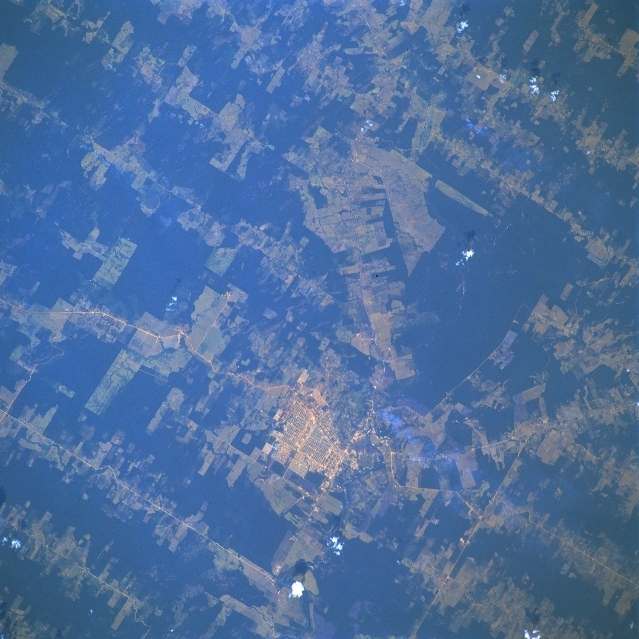 |
| STS046-103-053 Ariquemes, Rondonia, Brazil August 1992 The gridded street pattern of Ariquemes. (1990 estimated population 70000 and Rondonia's fourth largest city), is visible slightly below the center of the image. Part of Highway BR-364 the main highway (light-colored line) through the region can be traced diagonally across the image, as it passes along the east side of Ariquemes. The darker landscape is the natural rainforest canopy and the lighter-colored terrain shows the extent of the clear cutting for logging and agricultural purposes-either crop production or cattle ranching. Notice that practically all of the truncated roads (light colored lines) are very straight and parallel to one another, thereby creating a pattern in Rondonia that is unique to this region of Brazil. This view of deforestation in Rondonia, far western Brazil, (10.0S, 63.0W) is part of an agricultural resettlement project which ultimately covers an area about 80% the size of France. The patterns of deforestation in this part of the Amazon River Basin are usually aligned adjacent to highways, secondary roads, and streams for ease of access and transportation. Compare this view with the earlier 51G-37-062 for a comparison of deforestation in the region. |
| Images: | All Available Images Low-Resolution 348k |
|
| Mission: | STS046 |
|
| Roll - Frame: | 103 - 53 |
|
| Geographical Name: | BRAZIL |
|
| Features: | CLEAR CUTTING,CITIES |
|
| Center Lat x Lon: | N x E |
|
| Film Exposure: | N | N=Normal exposure, U=Under exposed, O=Over exposed, F=out of Focus |
| Percentage of Cloud Cover-CLDP: | 5 |
|
| Camera:: | HB |
|
| Camera Tilt: | LO=Low Oblique, HO=High Oblique, NV=Near Vertical |
|
| Camera Focal Length: | 250 |
|
| Nadir to Photo Center Direction: | The direction from the nadir to the center point, N=North, S=South, E=East, W=West |
|
| Stereo?: | N | Y=Yes there is an adjacent picture of the same area, N=No there isn't |
| Orbit Number: | 97 |
|
| Date: | 19920806 | YYYYMMDD |
| Time: | 164848 | GMT HHMMSS |
| Nadir Lat: | 9.8S |
Latitude of suborbital point of spacecraft |
| Nadir Lon: | 63W |
Longitude of suborbital point of spacecraft |
| Sun Azimuth: | 345 | Clockwise angle in degrees from north to the sun measured at the nadir point |
| Space Craft Altitude: | 124 | nautical miles |
| Sun Elevation: | 63 | Angle in degrees between the horizon and the sun, measured at the nadir point |
| Land Views: | FOREST |
|
| Water Views: | |
|
| Atmosphere Views: | |
|
| Man Made Views: | DEFORESTATION, HIGHWAY |
|
| City Views: | ARIQUEMES |
|
Photo is not associated with any sequences | ||
| NASA Home Page |
JSC Home Page |
JSC Digital Image Collection |
Earth Science & Remote Sensing |
|
This service is provided by the International Space Station program and the JSC Earth Science & Remote Sensing Unit, ARES Division, Exploration Integration Science Directorate.

|