Geographic Region: INDIAN OCEAN
Feature: OCEAN FEATURES, CLOUDS
|
Geographic Region: INDIAN OCEAN Feature: OCEAN FEATURES, CLOUDS |
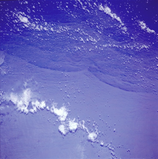 |
| STS044-079-077 Solitons, Indian Ocean November 1991 Internal waves (solitons) can be seen in this near-vertical photograph taken over the central Indian Ocean. Solitons are nonlinear, traveling waves that normally maintain their shape and identity. Ocean solitons (V-Brand waves, named after Vance Brand, the astronaut who discovered them on the Apollo-Soyuz flight in 1975) manifest themselves as large, subsurface, internal waves with little surface expression. This photograph was taken north of the Seychelles Islands near the northern limit of the subsurface Mascarene Ridge upon which the Seychelles are located. Numerous seamounts (submarine mountains) occur in this region. The photograph shows (near center) the solitons being refracted or impeded by a seamount. Seen in sunglint, these internal waves in the Indian ocean (4.0S, 56.5E) are refracting around a probable a sea mount on the Mascarene Plateau, NE of Madagascar. Internal waves are similar to surface waves, but they travel within the water column along the boundry between water layers of different density. On the surface, they appear as bands of smooth and rough water and `rom orbit, irregular light and dark bands. |
| Images: | All Available Images Low-Resolution 123k |
|
| Mission: | STS044 |
|
| Roll - Frame: | 79 - 77 |
|
| Geographical Name: | INDIAN OCEAN |
|
| Features: | OCEAN FEATURES, CLOUDS |
|
| Center Lat x Lon: | N x E |
|
| Film Exposure: | N | N=Normal exposure, U=Under exposed, O=Over exposed, F=out of Focus |
| Percentage of Cloud Cover-CLDP: | 10 |
|
| Camera:: | HB |
|
| Camera Tilt: | LO | LO=Low Oblique, HO=High Oblique, NV=Near Vertical |
| Camera Focal Length: | 250 |
|
| Nadir to Photo Center Direction: | The direction from the nadir to the center point, N=North, S=South, E=East, W=West |
|
| Stereo?: | Y | Y=Yes there is an adjacent picture of the same area, N=No there isn't |
| Orbit Number: | 22 |
|
| Date: | 19911126 | YYYYMMDD |
| Time: | 073254 | GMT HHMMSS |
| Nadir Lat: | 3.9S |
Latitude of suborbital point of spacecraft |
| Nadir Lon: | 56.6E |
Longitude of suborbital point of spacecraft |
| Sun Azimuth: | 202 | Clockwise angle in degrees from north to the sun measured at the nadir point |
| Space Craft Altitude: | 196 | nautical miles |
| Sun Elevation: | 61 | Angle in degrees between the horizon and the sun, measured at the nadir point |
| Land Views: | |
|
| Water Views: | OCEAN, INTERNAL WAVE |
|
| Atmosphere Views: | |
|
| Man Made Views: | |
|
| City Views: | |
|
Photo is not associated with any sequences | ||
| NASA Home Page |
JSC Home Page |
JSC Digital Image Collection |
Earth Science & Remote Sensing |
|
This service is provided by the International Space Station program and the JSC Earth Science & Remote Sensing Unit, ARES Division, Exploration Integration Science Directorate.

|