
Geographic Region: USA-OKLAHOMA
Feature: LAWTON,AFLDS,AGR,RED R.
|
Geographic Region: USA-OKLAHOMA Feature: LAWTON,AFLDS,AGR,RED R. |
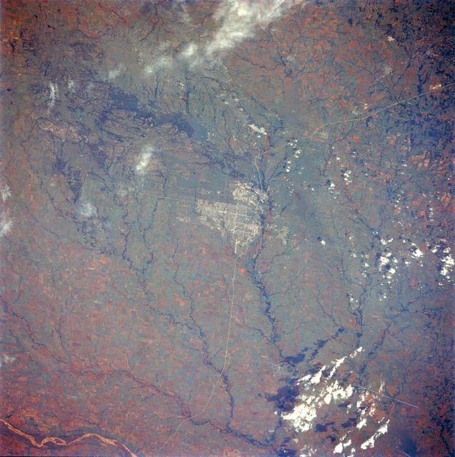 |
| STS040-074-068 Lawton, Oklahoma, U.S.A. June 1991 Lawton, with a population of more than 82 000, is featured in this low-oblique, south-looking photograph. Located in southwest Oklahoma, Lawton is a major commercial and trade center for the surrounding area; major products of the area include cotton, wheat, and cattle. Other manufacturing interests include cement products, flour, dairy products, iron ore, and limestone. Also, oil wells are scattered throughout the region. Fort Sill, a U.S. Army Field Artillery Center, is located north of Lawton (small airfield is visible). Several manmade and natural features are recognizable in the photograph--the Wichita Mountains northwest of the city; Lake Lawtonka (bluish-gray body of water on the eastern edge of the Wichita Mountains), which supplies water to both Fort Sill and Lawton; the H. E. Bailey Turnpike north and south of Lawton; the major runway of Lawton Airport south of the city; and a small portion of the Red River south-southwest of the city. |
| Images: | All Available Images Low-Resolution 165k |
|
| Mission: | STS040 |
|
| Roll - Frame: | 74 - 68 |
|
| Geographical Name: | USA-OKLAHOMA |
|
| Features: | LAWTON,AFLDS,AGR,RED R. |
|
| Center Lat x Lon: | 34.6N x 98.4W |
|
| Film Exposure: | N | N=Normal exposure, U=Under exposed, O=Over exposed, F=out of Focus |
| Percentage of Cloud Cover-CLDP: | 10 |
|
| Camera:: | HB |
|
| Camera Tilt: | 33 | LO=Low Oblique, HO=High Oblique, NV=Near Vertical |
| Camera Focal Length: | 250 |
|
| Nadir to Photo Center Direction: | S | The direction from the nadir to the center point, N=North, S=South, E=East, W=West |
| Stereo?: | N | Y=Yes there is an adjacent picture of the same area, N=No there isn't |
| Orbit Number: | 130 |
|
| Date: | 19910613 | YYYYMMDD |
| Time: | 152840 | GMT HHMMSS |
| Nadir Lat: | 36.2N |
Latitude of suborbital point of spacecraft |
| Nadir Lon: | 98W |
Longitude of suborbital point of spacecraft |
| Sun Azimuth: | 94 | Clockwise angle in degrees from north to the sun measured at the nadir point |
| Space Craft Altitude: | 151 | nautical miles |
| Sun Elevation: | 48 | Angle in degrees between the horizon and the sun, measured at the nadir point |
| Land Views: | PLAIN, HILL |
|
| Water Views: | LAKE |
|
| Atmosphere Views: | |
|
| Man Made Views: | URBAN AREA |
|
| City Views: | LAWTON |
|
Photo is not associated with any sequences | ||
| NASA Home Page |
JSC Home Page |
JSC Digital Image Collection |
Earth Science & Remote Sensing |
|
This service is provided by the International Space Station program and the JSC Earth Science & Remote Sensing Unit, ARES Division, Exploration Integration Science Directorate.

|