Geographic Region: SOUTH KOREA
Feature: POHANG, AFLD, COAST
|
Geographic Region: SOUTH KOREA Feature: POHANG, AFLD, COAST |
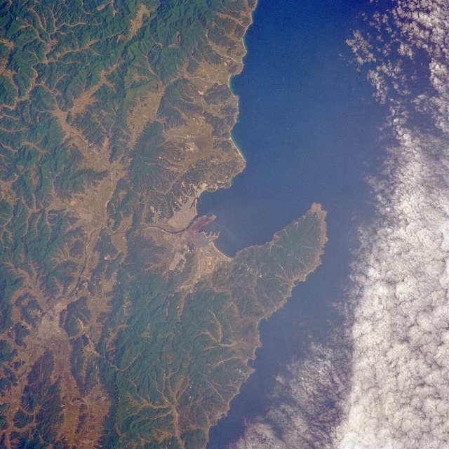 |
| STS040-072-043 P'ohang, South Korea June 1991 The seaport and industrial city of P'ohang is visible near the center of this near-vertical photograph. According to a 1980 census, P'ohang had a population of more than 200 000. Some of the city's infrastructure can be observed--the airport southeast of downtown, wharves jutting into Yongil Bay, and the industrial area (iron and steel mills) south of the river that flows into Yongil Bay. The topography of the southeast coastal area--many severe, steep slopes and low mountains--prevails throughout much of South Korea. Approximately 20 percent of the total land area is usable for agriculture. The dark green areas are hills and mountains with elevations ranging from 2000 to 4000 feet (600 to 1200 meters). Numerous valleys cutting through the mountain areas help map the rather complex drainage pattern found throughout South Korea. |
| Images: | All Available Images Low-Resolution 145k |
|
| Mission: | STS040 |
|
| Roll - Frame: | 72 - 43 |
|
| Geographical Name: | SOUTH KOREA |
|
| Features: | POHANG, AFLD, COAST |
|
| Center Lat x Lon: | 36.0N x 129.5E |
|
| Film Exposure: | N | N=Normal exposure, U=Under exposed, O=Over exposed, F=out of Focus |
| Percentage of Cloud Cover-CLDP: | 20 |
|
| Camera:: | HB |
|
| Camera Tilt: | 7 | LO=Low Oblique, HO=High Oblique, NV=Near Vertical |
| Camera Focal Length: | 250 |
|
| Nadir to Photo Center Direction: | W | The direction from the nadir to the center point, N=North, S=South, E=East, W=West |
| Stereo?: | N | Y=Yes there is an adjacent picture of the same area, N=No there isn't |
| Orbit Number: | 24 |
|
| Date: | 19910607 | YYYYMMDD |
| Time: | 000812 | GMT HHMMSS |
| Nadir Lat: | 35.9N |
Latitude of suborbital point of spacecraft |
| Nadir Lon: | 129.8E |
Longitude of suborbital point of spacecraft |
| Sun Azimuth: | 94 | Clockwise angle in degrees from north to the sun measured at the nadir point |
| Space Craft Altitude: | 154 | nautical miles |
| Sun Elevation: | 46 | Angle in degrees between the horizon and the sun, measured at the nadir point |
| Land Views: | MOUNTAIN, FOREST, PENINSULA, COAST |
|
| Water Views: | BAY |
|
| Atmosphere Views: | |
|
| Man Made Views: | URBAN AREA |
|
| City Views: | |
|
Photo is not associated with any sequences | ||
| NASA Home Page |
JSC Home Page |
JSC Digital Image Collection |
Earth Science & Remote Sensing |
|
This service is provided by the International Space Station program and the JSC Earth Science & Remote Sensing Unit, ARES Division, Exploration Integration Science Directorate.

|