
Geographic Region: USA-WEST VIRGINIA
Feature: MARTINSBURG WV. AREA
|
Geographic Region: USA-WEST VIRGINIA Feature: MARTINSBURG WV. AREA |
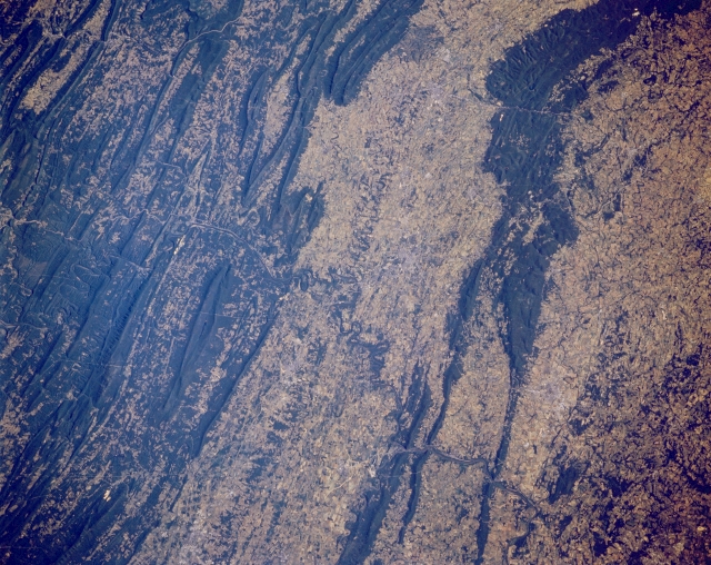 |
| STS040-152-127 Potomac River, Appalachian Mountains, West Virginia/Maryland, U.S.A. June 1991 The Potomac River flows southeastward (left center to lower right) across this north-looking low-oblique view. South of the Potomac near the center of the image, is the northern extension of the Shenandoah River Valley of Virginia and West Virginia. North of the Potomac River is the southwestern extension of the Cumberland Valley of Maryland and Pennsylvania. To the west (left) of the Shenandoah and Cumberland Valleys are the gently rolling, folded Appalachian Mountains, covered by the most varied deciduous forest in North America. To the east of the Shenandoah and Cumberland Valleys are the linear Blue Ridge Mountains. The valleys between the folded mountains are fertile agricultural regions. |
| Images: | All Available Images Low-Resolution 343k |
|
| Mission: | STS040 |
|
| Roll - Frame: | 152 - 127 |
|
| Geographical Name: | USA-WEST VIRGINIA |
|
| Features: | MARTINSBURG WV. AREA |
|
| Center Lat x Lon: | 39.5N x 77.5W |
|
| Film Exposure: | N | N=Normal exposure, U=Under exposed, O=Over exposed, F=out of Focus |
| Percentage of Cloud Cover-CLDP: | 0 |
|
| Camera:: | LH |
|
| Camera Tilt: | 13 | LO=Low Oblique, HO=High Oblique, NV=Near Vertical |
| Camera Focal Length: | 90 |
|
| Nadir to Photo Center Direction: | NE | The direction from the nadir to the center point, N=North, S=South, E=East, W=West |
| Stereo?: | N | Y=Yes there is an adjacent picture of the same area, N=No there isn't |
| Orbit Number: | 128 |
|
| Date: | 19910613 | YYYYMMDD |
| Time: | 122321 | GMT HHMMSS |
| Nadir Lat: | 39.1N |
Latitude of suborbital point of spacecraft |
| Nadir Lon: | 77.9W |
Longitude of suborbital point of spacecraft |
| Sun Azimuth: | 81 | Clockwise angle in degrees from north to the sun measured at the nadir point |
| Space Craft Altitude: | 150 | nautical miles |
| Sun Elevation: | 27 | Angle in degrees between the horizon and the sun, measured at the nadir point |
| Land Views: | MOUNTAIN, FOREST |
|
| Water Views: | RIVER |
|
| Atmosphere Views: | |
|
| Man Made Views: | AGRICULTURE |
|
| City Views: | |
|
Photo is not associated with any sequences | ||
| NASA Home Page |
JSC Home Page |
JSC Digital Image Collection |
Earth Science & Remote Sensing |
|
This service is provided by the International Space Station program and the JSC Earth Science & Remote Sensing Unit, ARES Division, Exploration Integration Science Directorate.

|