
Geographic Region: USA-CALIFORNIA
Feature: SAN JOAQUIN VLY,FRESNO
|
Geographic Region: USA-CALIFORNIA Feature: SAN JOAQUIN VLY,FRESNO |
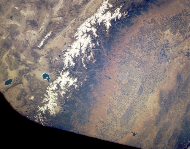 |
| STS040-151-002 Central Sierra Nevada Mountains, California, U.S.A. June 1991 Although part of the photograph is obscured by the Shuttle window (blackness along upper left), the Sierra Nevadas are discernible. The green, irrigated San Joaquin Valley and its reservoirs contrast markedly with the arid conditions of the sparsely vegetated east side of the Sierra Nevada Range. The western slopes are more gradual than the precipitous eastern slopes and are characterized by a series of east-west trending, deeply eroded streams and canyons that transport large quantities of snowmelt. To the east, the Owens River Valley separates the Sierra Nevadas from the White Mountains, whose crest exceeds 14 000 feet (4265 meters). The White Mountains area is so cold, dry, and high that it qualifies as a cold desert. Apparent east of the Sierra Nevadas are Mono Lake and Walker Lake. |
| Images: | All Available Images Low-Resolution 272k |
|
| Mission: | STS040 |
|
| Roll - Frame: | 151 - 2 |
|
| Geographical Name: | USA-CALIFORNIA |
|
| Features: | SAN JOAQUIN VLY,FRESNO |
|
| Center Lat x Lon: | 37.0N x 119W |
|
| Film Exposure: | N | N=Normal exposure, U=Under exposed, O=Over exposed, F=out of Focus |
| Percentage of Cloud Cover-CLDP: | 0 |
|
| Camera:: | LH |
|
| Camera Tilt: | 3 | LO=Low Oblique, HO=High Oblique, NV=Near Vertical |
| Camera Focal Length: | 90 |
|
| Nadir to Photo Center Direction: | NE | The direction from the nadir to the center point, N=North, S=South, E=East, W=West |
| Stereo?: | N | Y=Yes there is an adjacent picture of the same area, N=No there isn't |
| Orbit Number: | 35 |
|
| Date: | 19910607 | YYYYMMDD |
| Time: | 164025 | GMT HHMMSS |
| Nadir Lat: | 36.9N |
Latitude of suborbital point of spacecraft |
| Nadir Lon: | 119.1W |
Longitude of suborbital point of spacecraft |
| Sun Azimuth: | 94 | Clockwise angle in degrees from north to the sun measured at the nadir point |
| Space Craft Altitude: | 153 | nautical miles |
| Sun Elevation: | 45 | Angle in degrees between the horizon and the sun, measured at the nadir point |
| Land Views: | MOUNTAIN, FAULT, VALLEY |
|
| Water Views: | LAKE |
|
| Atmosphere Views: | |
|
| Man Made Views: | AGRICULTURE |
|
| City Views: | |
|
Photo is not associated with any sequences | ||
| NASA Home Page |
JSC Home Page |
JSC Digital Image Collection |
Earth Science & Remote Sensing |
|
This service is provided by the International Space Station program and the JSC Earth Science & Remote Sensing Unit, ARES Division, Exploration Integration Science Directorate.

|