
Geographic Region: USA-ARIZONA
Feature: PAN. COLORADO R.,UT. TO CA
|
Geographic Region: USA-ARIZONA Feature: PAN. COLORADO R.,UT. TO CA |
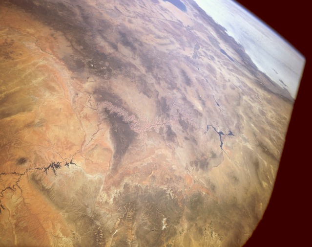 |
| STS040-151-014 The Grand Canyon of the Colorado River, Arizona, Utah, Nevada, and California, U.S.A. June 1991 The Grand Canyon can be seen near the center of this southwest-looking, high-oblique photograph. This panoramic view of the southwestern United States shows the course of the Colorado River as it traverses from Lake Powell in southern Utah, through the Grand Canyon, westward to Lake Mead in eastern Nevada, and then southward to Mexico and the Gulf of California. The dark forested areas on either side of the Grand Canyon are the Kaibab Plateau to the north and the Coconino Plateau to the south. Snow-covered Humphreys Peak of the San Francisco Peaks is visible south of the Coconino Plateau. Just south of the mountains is the tree-covered Mogollon Rim. The bright orangish-red sands of the Painted Desert can be seen east of the Grand Canyon. The forested Wasatch Mountain Range of southern Utah is visible north of the Kaibab Plateau. Southwest of Lake Mead, the Salton Sea and the Imperial Valley of southern California can be seen. West of the Salton Sea, clouds cover the Pacific Ocean. |
| Images: | All Available Images Low-Resolution 87k |
|
| Mission: | STS040 |
|
| Roll - Frame: | 151 - 14 |
|
| Geographical Name: | USA-ARIZONA |
|
| Features: | PAN. COLORADO R.,UT. TO CA |
|
| Center Lat x Lon: | 34.5N x 113W |
|
| Film Exposure: | N | N=Normal exposure, U=Under exposed, O=Over exposed, F=out of Focus |
| Percentage of Cloud Cover-CLDP: | 10 |
|
| Camera:: | LH |
|
| Camera Tilt: | HO | LO=Low Oblique, HO=High Oblique, NV=Near Vertical |
| Camera Focal Length: | 90 |
|
| Nadir to Photo Center Direction: | S | The direction from the nadir to the center point, N=North, S=South, E=East, W=West |
| Stereo?: | N | Y=Yes there is an adjacent picture of the same area, N=No there isn't |
| Orbit Number: | 35 |
|
| Date: | 19910607 | YYYYMMDD |
| Time: | 164207 | GMT HHMMSS |
| Nadir Lat: | 38.3N |
Latitude of suborbital point of spacecraft |
| Nadir Lon: | 111.1W |
Longitude of suborbital point of spacecraft |
| Sun Azimuth: | 102 | Clockwise angle in degrees from north to the sun measured at the nadir point |
| Space Craft Altitude: | 154 | nautical miles |
| Sun Elevation: | 52 | Angle in degrees between the horizon and the sun, measured at the nadir point |
| Land Views: | BASIN, DESERT, VALLEY, PLATEAU |
|
| Water Views: | RIVER, LAKE |
|
| Atmosphere Views: | |
|
| Man Made Views: | DAM, AGRICULTURE |
|
| City Views: | |
|
Photo is not associated with any sequences | ||
| NASA Home Page |
JSC Home Page |
JSC Digital Image Collection |
Earth Science & Remote Sensing |
|
This service is provided by the International Space Station program and the JSC Earth Science & Remote Sensing Unit, ARES Division, Exploration Integration Science Directorate.

|