Geographic Region: SAUDI ARABIA
Feature: JIDDAH, MECCA, COAST
|
Geographic Region: SAUDI ARABIA Feature: JIDDAH, MECCA, COAST |
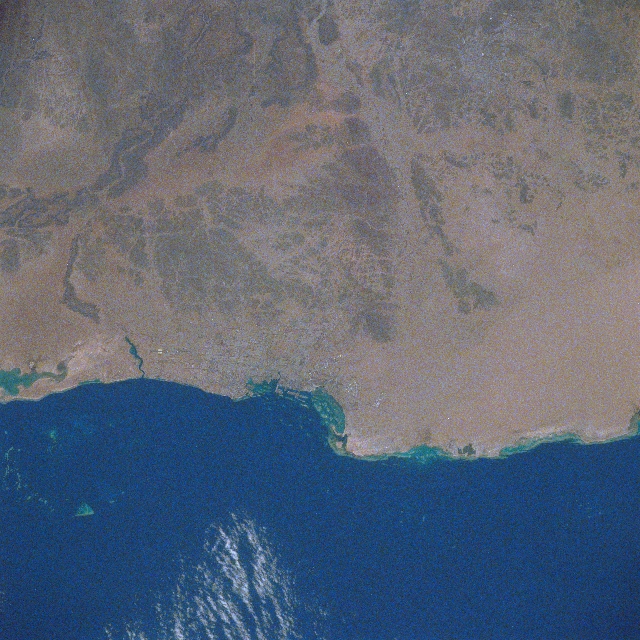 |
| STS037-082-091 Mecca-Jiddah Area, Saudi Arabia April 1991 Two of Saudi Arabia's most important cities, Mecca (top center) and Jiddah (near center) are visible near the central west coast of Saudi Arabia along the eastern edge of the Red Sea. Mecca, with approximately 600000 permanent inhabitants, is the most holy city in all of Islam. Mecca is located approximately 50 miles (80 km) east of the port city of Jiddah. Jiddah (some of urban infrastructure is visible) is a busy, clean, ultra modern port facility through which large quantities of assorted goods and people enter and leave Saudi Arabia. With almost 2 million people, Jiddah is the second largest city in Saudi Arabia (second only to Riyadh, the capital city). The darker colored terrain immediately east of Jiddah shows an area of low hills. The dark band across the top of the image is part of the Hijaz Mountains that parallel the west coast of Saudi Arabia. The region is generally arid (sandy coastal and valleys) but becomes semiarid on some of the higher elevations. The lighter-colored landscape is predominantly sandy features, while the darker landscapes are rock outcrops and higher elevations. The major highway artery that connects Jiddah with Mecca can be traced eastward through the sandy valley southwest of Jiddah. |
| Images: | All Available Images Low-Resolution 383k |
|
| Mission: | STS037 |
|
| Roll - Frame: | 82 - 91 |
|
| Geographical Name: | SAUDI ARABIA |
|
| Features: | JIDDAH, MECCA, COAST |
|
| Center Lat x Lon: | 21.5N x 39.2E |
|
| Film Exposure: | N | N=Normal exposure, U=Under exposed, O=Over exposed, F=out of Focus |
| Percentage of Cloud Cover-CLDP: | 5 |
|
| Camera:: | HB |
|
| Camera Tilt: | 27 | LO=Low Oblique, HO=High Oblique, NV=Near Vertical |
| Camera Focal Length: | 250 |
|
| Nadir to Photo Center Direction: | N | The direction from the nadir to the center point, N=North, S=South, E=East, W=West |
| Stereo?: | Y | Y=Yes there is an adjacent picture of the same area, N=No there isn't |
| Orbit Number: | 13 |
|
| Date: | 19910406 | YYYYMMDD |
| Time: | 091945 | GMT HHMMSS |
| Nadir Lat: | 19.6N |
Latitude of suborbital point of spacecraft |
| Nadir Lon: | 38.3E |
Longitude of suborbital point of spacecraft |
| Sun Azimuth: | 170 | Clockwise angle in degrees from north to the sun measured at the nadir point |
| Space Craft Altitude: | 245 | nautical miles |
| Sun Elevation: | 77 | Angle in degrees between the horizon and the sun, measured at the nadir point |
| Land Views: | MOUNTAIN, HILL |
|
| Water Views: | SEA |
|
| Atmosphere Views: | |
|
| Man Made Views: | URBAN AREA, PORT |
|
| City Views: | |
|
Photo is not associated with any sequences | ||
| NASA Home Page |
JSC Home Page |
JSC Digital Image Collection |
Earth Science & Remote Sensing |
|
This service is provided by the International Space Station program and the JSC Earth Science & Remote Sensing Unit, ARES Division, Exploration Integration Science Directorate.

|