Geographic Region: AUSTRALIA-WA
Feature: SHARK BAY
|
Geographic Region: AUSTRALIA-WA Feature: SHARK BAY |
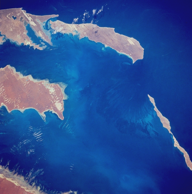 |
| STS035-076-035 Shark Bay, Western Australia, Australia December 1990 Shark Bay is a large body of water along the west coast of Western Australia. The central part of the bay is shown here in the center of the image. Dirk Hartog Island, the westernmost land of Australia, borders the bay to the southwest (upper left) and Dorre and Bernier Islands (thin, elongated islands--bottom right) form a barrier between Shark Bay and the Indian Ocean. Peron Peninsula is the land area (middle left side) that juts northward into the middle of the bay. The light colored strips of land on the peninsulas and islands are exposed sand dunes that are aligned with the prevailing wind direction. Shark Bay is noted for its unique formations and features of exceptional natural beauty. The bay also provides an important habitat for threatened animals such as the dugongs. |
| Images: | All Available Images Low-Resolution 283k |
|
| Mission: | STS035 |
|
| Roll - Frame: | 76 - 35 |
|
| Geographical Name: | AUSTRALIA-WA |
|
| Features: | SHARK BAY |
|
| Center Lat x Lon: | 25.5S x 113.5E |
|
| Film Exposure: | N | N=Normal exposure, U=Under exposed, O=Over exposed, F=out of Focus |
| Percentage of Cloud Cover-CLDP: | 5 |
|
| Camera:: | HB |
|
| Camera Tilt: | 44 | LO=Low Oblique, HO=High Oblique, NV=Near Vertical |
| Camera Focal Length: | 250 |
|
| Nadir to Photo Center Direction: | S | The direction from the nadir to the center point, N=North, S=South, E=East, W=West |
| Stereo?: | Y | Y=Yes there is an adjacent picture of the same area, N=No there isn't |
| Orbit Number: | 94 |
|
| Date: | 19901208 | YYYYMMDD |
| Time: | 052838 | GMT HHMMSS |
| Nadir Lat: | 22.5S |
Latitude of suborbital point of spacecraft |
| Nadir Lon: | 113.2E |
Longitude of suborbital point of spacecraft |
| Sun Azimuth: | 265 | Clockwise angle in degrees from north to the sun measured at the nadir point |
| Space Craft Altitude: | 188 | nautical miles |
| Sun Elevation: | 73 | Angle in degrees between the horizon and the sun, measured at the nadir point |
| Land Views: | PENINSULA |
|
| Water Views: | BAY |
|
| Atmosphere Views: | |
|
| Man Made Views: | |
|
| City Views: | |
|
Photo is not associated with any sequences | ||
| NASA Home Page |
JSC Home Page |
JSC Digital Image Collection |
Earth Science & Remote Sensing |
|
This service is provided by the International Space Station program and the JSC Earth Science & Remote Sensing Unit, ARES Division, Exploration Integration Science Directorate.

|