Geographic Region: ARGENTINA
Feature: DE LA PLATA RIVER
|
Geographic Region: ARGENTINA Feature: DE LA PLATA RIVER |
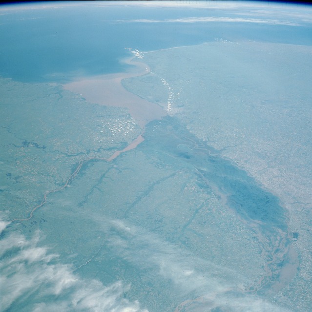 |
| STS035-073-039 Rio de la Plata, Argentina December 1990 In addition to the Atlantic Ocean (eastern horizon), three important water features of Argentina's central east coast are apparent in this high-oblique, southeast-looking photograph--the Paraná River (South America's second largest drainage basin), the southward-flowing Uruguay River, and the muddy Rio de la Plata. Paraná's delta, measuring more than 175 miles (275 kilometers) in length and averaging 30 miles (50 kilometers) in width, appears dark green in this northwest-southeast orientation. The delta is composed of numerous meandering and interbraided streams and channels that make it subject to occasional severe flooding. The silt-laden main watercourse is observable at various points within this flood prone area. The southward-flowing Uruguay River, which has a very high level of sediment, passes east of the mouth of the Paraná River delta. The merging of these two rivers with their high levels of silt almost always produces an extremely muddy Rio de la Plata. The interfluvial area of the Paraná and Uruguay Rivers, known as the Mesopotamia of South America, is composed of floodplain and gently rolling, well-drained land. Montevideo, capital of Uruguay near the northeast limit of the Rio de la Plata, and Buenos Aires, capital of Argentina at the southern end of the Paraná River delta, are not identifiable on this scale. |
| Images: | All Available Images Low-Resolution 89k |
|
| Mission: | STS035 |
|
| Roll - Frame: | 73 - 39 |
|
| Geographical Name: | ARGENTINA |
|
| Features: | DE LA PLATA RIVER |
|
| Center Lat x Lon: | 33.5S x 59W |
|
| Film Exposure: | N | N=Normal exposure, U=Under exposed, O=Over exposed, F=out of Focus |
| Percentage of Cloud Cover-CLDP: | 15 |
|
| Camera:: | HB |
|
| Camera Tilt: | HO | LO=Low Oblique, HO=High Oblique, NV=Near Vertical |
| Camera Focal Length: | 100 |
|
| Nadir to Photo Center Direction: | S | The direction from the nadir to the center point, N=North, S=South, E=East, W=West |
| Stereo?: | N | Y=Yes there is an adjacent picture of the same area, N=No there isn't |
| Orbit Number: | 23 |
|
| Date: | 19901203 | YYYYMMDD |
| Time: | 171126 | GMT HHMMSS |
| Nadir Lat: | 28.5S |
Latitude of suborbital point of spacecraft |
| Nadir Lon: | 61.2W |
Longitude of suborbital point of spacecraft |
| Sun Azimuth: | 285 | Clockwise angle in degrees from north to the sun measured at the nadir point |
| Space Craft Altitude: | 190 | nautical miles |
| Sun Elevation: | 71 | Angle in degrees between the horizon and the sun, measured at the nadir point |
| Land Views: | COAST, PLAIN, VALLEY |
|
| Water Views: | DELTA, SWAMP, RIVER, SEDIMENT, ESTUARY |
|
| Atmosphere Views: | |
|
| Man Made Views: | AGRICULTURE |
|
| City Views: | |
|
Photo is not associated with any sequences | ||
| NASA Home Page |
JSC Home Page |
JSC Digital Image Collection |
Earth Science & Remote Sensing |
|
This service is provided by the International Space Station program and the JSC Earth Science & Remote Sensing Unit, ARES Division, Exploration Integration Science Directorate.

|