
Geographic Region: USA-NORTH CAROLINA
Feature: CAPE HATTERAS
|
Geographic Region: USA-NORTH CAROLINA Feature: CAPE HATTERAS |
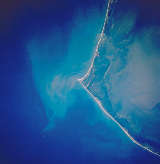 |
| STS034-83-69 Cape Hatteras, North Carolina, U.S.A. October 1989 The famous barrier island coast of Cape Hatteras, is visible in this near vertical of the North Carolina coast. This barrier island system is protected as the Cape Hatteras National Seashore, with Pamlico Sound to the west and the Atlantic Ocean to the east. A plume of sediment, visible off of the tip of Cape Hatteras, creates a light blue color in the Atlantic Ocean waters. This outflow is from the precipitation runoff of Hurricane Hugo (Sept. 1989) which was still evident during the STS-34 mission (Oct. 1989). This same delayed or extended runoff phenomenon was also very marked along the periphery of the Yucatan Peninsula following Hurricane Gilbert in 1988. |
| Images: | All Available Images Low-Resolution 259k |
|
| Mission: | STS034 |
|
| Roll - Frame: | 83 - 69 |
|
| Geographical Name: | USA-NORTH CAROLINA |
|
| Features: | CAPE HATTERAS |
|
| Center Lat x Lon: | 35.0N x 75.5W |
|
| Film Exposure: | N | N=Normal exposure, U=Under exposed, O=Over exposed, F=out of Focus |
| Percentage of Cloud Cover-CLDP: | 0 |
|
| Camera:: | HB |
|
| Camera Tilt: | 12 | LO=Low Oblique, HO=High Oblique, NV=Near Vertical |
| Camera Focal Length: | 250 |
|
| Nadir to Photo Center Direction: | N | The direction from the nadir to the center point, N=North, S=South, E=East, W=West |
| Stereo?: | Y | Y=Yes there is an adjacent picture of the same area, N=No there isn't |
| Orbit Number: | 49 |
|
| Date: | 19891021 | YYYYMMDD |
| Time: | 173853 | GMT HHMMSS |
| Nadir Lat: | 34.4N |
Latitude of suborbital point of spacecraft |
| Nadir Lon: | 75.3W |
Longitude of suborbital point of spacecraft |
| Sun Azimuth: | 197 | Clockwise angle in degrees from north to the sun measured at the nadir point |
| Space Craft Altitude: | 177 | nautical miles |
| Sun Elevation: | 43 | Angle in degrees between the horizon and the sun, measured at the nadir point |
| Land Views: | CAPE, ISLAND |
|
| Water Views: | OCEAN, ESTUARY, INLET |
|
| Atmosphere Views: | |
|
| Man Made Views: | |
|
| City Views: | |
|
Photo is not associated with any sequences | ||
| NASA Home Page |
JSC Home Page |
JSC Digital Image Collection |
Earth Science & Remote Sensing |
|
This service is provided by the International Space Station program and the JSC Earth Science & Remote Sensing Unit, ARES Division, Exploration Integration Science Directorate.

|