Geographic Region: INDONESIA
Feature: TIMOR
|
Geographic Region: INDONESIA Feature: TIMOR |
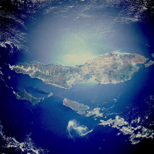 |
| STS033-082-071 Timor Island, Indonesia November 1989 Timor Island, one of the larger islands of the Lesser Sunda Islands, is located between the Savu Sea to the northwest and the Timor Sea to the southeast. The western half of the island, under Dutch control until 1949, and the eastern half, a Portuguese province until 1975, are now united as a province of Indonesia. Timor Island is approximately 300 miles (480 kilometers) long and 10 to 65 miles (16 to 105 kilometers) wide. Timor and the north-northwest arc of islands around the eastern end of the Banda Sea, all volcanic in origin, are in an unstable region of the world because of the intersection of three major tectonic plates northeast near Irian Jaya, Indonesia. Although it is located in the tropics, Timor Island has a definite dry season during the winter. Large forested volcanic mountains exist; however, much of the landscape lacks dense stands of tropical forest or jungle. Major cash crops include coffee, sandalwood, and copra. This almost totally cloud free, photo of the island of Timor, Indonesia (9.0S, 125.0E) illustrates the volcanic origin of the over 1500 islands of Indonesia. Close examination of the photo reveals several eroded volcanoes on the Island of Timor and several of the adjacent islands. The linear alignment of the volcanoes, as seen from space, indicates the edges of the tectonic plates of the Earth's crust where volcanic activity is most common. |
| Images: | All Available Images Low-Resolution 142k |
|
| Mission: | STS033 |
|
| Roll - Frame: | 82 - 71 |
|
| Geographical Name: | INDONESIA |
|
| Features: | TIMOR |
|
| Center Lat x Lon: | 9S x 125.0E |
|
| Film Exposure: | N | N=Normal exposure, U=Under exposed, O=Over exposed, F=out of Focus |
| Percentage of Cloud Cover-CLDP: | 25 |
|
| Camera:: | HB |
|
| Camera Tilt: | 12 | LO=Low Oblique, HO=High Oblique, NV=Near Vertical |
| Camera Focal Length: | 40 |
|
| Nadir to Photo Center Direction: | E | The direction from the nadir to the center point, N=North, S=South, E=East, W=West |
| Stereo?: | Y | Y=Yes there is an adjacent picture of the same area, N=No there isn't |
| Orbit Number: | 33 |
|
| Date: | 19891125 | YYYYMMDD |
| Time: | 023530 | GMT HHMMSS |
| Nadir Lat: | 9.3S |
Latitude of suborbital point of spacecraft |
| Nadir Lon: | 124.3E |
Longitude of suborbital point of spacecraft |
| Sun Azimuth: | 133 | Clockwise angle in degrees from north to the sun measured at the nadir point |
| Space Craft Altitude: | 209 | nautical miles |
| Sun Elevation: | 73 | Angle in degrees between the horizon and the sun, measured at the nadir point |
| Land Views: | ISLAND, MOUNTAIN, FOREST, VOLCANO |
|
| Water Views: | RIVER, SEA, SUNGLINT |
|
| Atmosphere Views: | |
|
| Man Made Views: | AGRICULTURE, DEFORESTATION |
|
| City Views: | |
|
Photo is not associated with any sequences | ||
| NASA Home Page |
JSC Home Page |
JSC Digital Image Collection |
Earth Science & Remote Sensing |
|
This service is provided by the International Space Station program and the JSC Earth Science & Remote Sensing Unit, ARES Division, Exploration Integration Science Directorate.

|