Geographic Region: MADAGASCAR
Feature: MANGOKY RIVER,LAC IHOTRY
|
Geographic Region: MADAGASCAR Feature: MANGOKY RIVER,LAC IHOTRY |
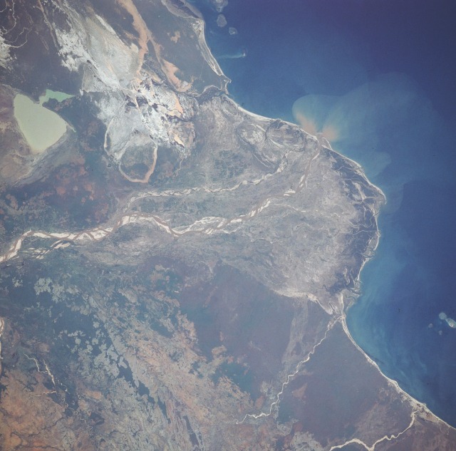 |
| STS033-71-94 Mangoky River Delta, Madagascar November 1989 This low-oblique, southwest-looking photograph reveals the delta of the Mangoky River and the surrounding coastal plain. The Mangoky River is 350 miles (564 kilometers) long and rises in the Central Highlands of Madagascar just east of the city of Fianarantsoa. The river flows generally in a westerly direction out of the highlands, crosses the southern extension of the Bemaraha Plateau, reaches the coastal plain and its delta, and enters the Mozambique Channel north of the city of Morombe (city not shown in the photograph). Most of Madagascar has undergone serious deforestation during the last 40 years. Soil erosion has been extreme, as evidenced by the many sandbars located within the Mangoky River channel. Silt-laden, greenish-tan Lake Ihotry is clearly discernible south of the river. Between the lake and the coast is a rather large, whitish area of sand interspersed with silt-laden ponds. The southern portion of the delta is dominated by successive barrier island and spit formation. In contrast, the northern, protected portion of the delta is dominated by tidal passes and mangrove swamps. |
| Images: | All Available Images Low-Resolution 111k |
|
| Mission: | STS033 |
|
| Roll - Frame: | 71 - 94 |
|
| Geographical Name: | MADAGASCAR |
|
| Features: | MANGOKY RIVER,LAC IHOTRY |
|
| Center Lat x Lon: | 21.5S x 43.5E |
|
| Film Exposure: | N | N=Normal exposure, U=Under exposed, O=Over exposed, F=out of Focus |
| Percentage of Cloud Cover-CLDP: | 0 |
|
| Camera:: | HB |
|
| Camera Tilt: | 5 | LO=Low Oblique, HO=High Oblique, NV=Near Vertical |
| Camera Focal Length: | 250 |
|
| Nadir to Photo Center Direction: | N | The direction from the nadir to the center point, N=North, S=South, E=East, W=West |
| Stereo?: | Y | Y=Yes there is an adjacent picture of the same area, N=No there isn't |
| Orbit Number: | 20 |
|
| Date: | 19891124 | YYYYMMDD |
| Time: | 062718 | GMT HHMMSS |
| Nadir Lat: | 21.8S |
Latitude of suborbital point of spacecraft |
| Nadir Lon: | 43.6E |
Longitude of suborbital point of spacecraft |
| Sun Azimuth: | 95 | Clockwise angle in degrees from north to the sun measured at the nadir point |
| Space Craft Altitude: | 240 | nautical miles |
| Sun Elevation: | 56 | Angle in degrees between the horizon and the sun, measured at the nadir point |
| Land Views: | COAST |
|
| Water Views: | RIVER, DELTA, LAKE, SEDIMENT, SWAMP |
|
| Atmosphere Views: | |
|
| Man Made Views: | |
|
| City Views: | |
|
Photo is not associated with any sequences | ||
| NASA Home Page |
JSC Home Page |
JSC Digital Image Collection |
Earth Science & Remote Sensing |
|
This service is provided by the International Space Station program and the JSC Earth Science & Remote Sensing Unit, ARES Division, Exploration Integration Science Directorate.

|