Geographic Region: ETHIOPIA
Feature: L. SHALA,L. ZIWAY,L. AWASA
|
Geographic Region: ETHIOPIA Feature: L. SHALA,L. ZIWAY,L. AWASA |
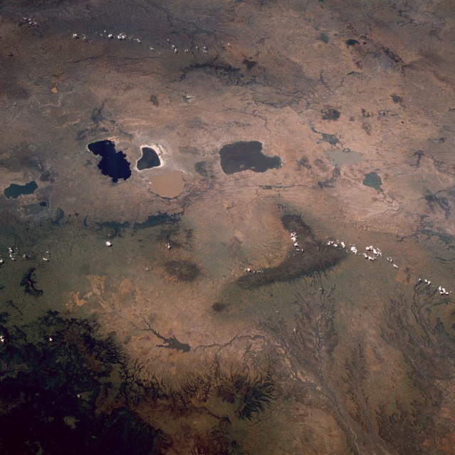 |
| STS032-071-0AD East Africa Rift Valley, Ethiopia January 1990 The Great Rift Valley of east Africa extends through the midsection of Ethiopia as a northeast-southwest-trending elevated plateau. The average elevation above sea level for this part of the valley is 7000 feet (2130 meters). The valley floor is easily identified by a series of sizable lakes that have formed as water collects at the base of this extensive depression. Six major lakes of various shapes and colors approximately 110 miles (180 kilometers) due south of the capital city of Addis Ababa are visible in this photograph. Some volcanoes can be identified primarily from the drainage patterns that radiate in all directions from their craters. The large, dark L-shaped mountainous area east of the lakes is also volcanic in origin, its massive eroded drainage pattern very evident as the landscape falls away to lower elevations. This drainage basin is part of the Shebelle River that drains eastern Ethiopia, intermittently flows through central Somalia, and empties into the Indian Ocean. The darker area along the southeastern corner of the photograph is a vegetated, mountainous region where several elevations exceed 12 000 feet (3660 meters) above sea level. |
| Images: | All Available Images Low-Resolution 126k |
|
| Mission: | STS032 |
|
| Roll - Frame: | 71 - AD |
|
| Geographical Name: | ETHIOPIA |
|
| Features: | L. SHALA,L. ZIWAY,L. AWASA |
|
| Center Lat x Lon: | 7.5N x 39.0E |
|
| Film Exposure: | N | N=Normal exposure, U=Under exposed, O=Over exposed, F=out of Focus |
| Percentage of Cloud Cover-CLDP: | 10 |
|
| Camera:: | HB |
|
| Camera Tilt: | LO | LO=Low Oblique, HO=High Oblique, NV=Near Vertical |
| Camera Focal Length: | 100 |
|
| Nadir to Photo Center Direction: | The direction from the nadir to the center point, N=North, S=South, E=East, W=West |
|
| Stereo?: | Y | Y=Yes there is an adjacent picture of the same area, N=No there isn't |
| Orbit Number: | |
|
| Date: | 199001__ | YYYYMMDD |
| Time: | GMT HHMMSS |
|
| Nadir Lat: | N |
Latitude of suborbital point of spacecraft |
| Nadir Lon: | E |
Longitude of suborbital point of spacecraft |
| Sun Azimuth: | Clockwise angle in degrees from north to the sun measured at the nadir point |
|
| Space Craft Altitude: | nautical miles |
|
| Sun Elevation: | Angle in degrees between the horizon and the sun, measured at the nadir point |
|
| Land Views: | VALLEY, PLATEAU, VOLCANO, BASIN, ESCARPMENT, FOREST, MOUNTAIN |
|
| Water Views: | LAKE, RIVER |
|
| Atmosphere Views: | |
|
| Man Made Views: | AGRICULTURE |
|
| City Views: | |
|
Photo is not associated with any sequences | ||
| NASA Home Page |
JSC Home Page |
JSC Digital Image Collection |
Earth Science & Remote Sensing |
|
This service is provided by the International Space Station program and the JSC Earth Science & Remote Sensing Unit, ARES Division, Exploration Integration Science Directorate.

|