 Photo #: STS030-87-42 Date: May 1989
Geographic Region: NIGER
Feature: AIR MOUNTAINS

 Photo #: STS030-87-42 Date: May 1989 Photo #: STS030-87-42 Date: May 1989Geographic Region: NIGER Feature: AIR MOUNTAINS |
 |
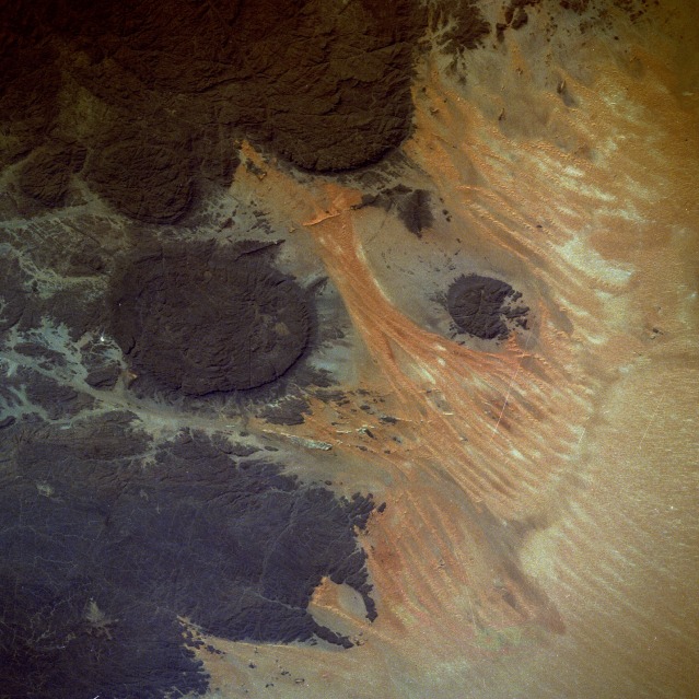
| STS030-87-42 Northeastern Air Mountains, Niger May 1989 The Air Mountains of north-central Niger terminate abruptly at the western edge of the Tenere Desert. This area of Niger, also known as the Air Plateau, is composed of tilted sedimentary rocks and striking ring complexes of volcanic rocks. These dark-colored rock surfaces contrast dramatically with the surrounding light-colored, sand-covered plains that lie approximately 1000 feet (300 meters) above sea level. The elevations of the Air Plateau vary from 1500 feet (450 meters) to over 5000 feet (1500 meters) above sea level. This part of the Sahara Desert was proclaimed "Switzerland of the Desert" by a German explorer because this region offers a welcome contrast to the overwhelming monotony of the sand seas that abound in the Sahara. The aridity of the region offers a classic environment for monitoring the effects of wind erosion. A few nomadic people live in some of the valleys, but their numbers have been constantly decreasing for several decades. Even the recent discovery of uranium in this region may not prove to be enough inducement to reverse the decreasing population trend. |
| Images: | All Available Images Low-Resolution 136k |
|
| Mission: | STS030 |
|
| Roll - Frame: | 87 - 42 |
|
| Geographical Name: | NIGER |
|
| Features: | AIR MOUNTAINS |
|
| Center Lat x Lon: | 19.0N x 9.0E |
|
| Film Exposure: | N | N=Normal exposure, U=Under exposed, O=Over exposed, F=out of Focus |
| Percentage of Cloud Cover-CLDP: | 0 |
|
| Camera:: | HB |
|
| Camera Tilt: | 41 | LO=Low Oblique, HO=High Oblique, NV=Near Vertical |
| Camera Focal Length: | 250 |
|
| Nadir to Photo Center Direction: | SE | The direction from the nadir to the center point, N=North, S=South, E=East, W=West |
| Stereo?: | N | Y=Yes there is an adjacent picture of the same area, N=No there isn't |
| Orbit Number: | 46 |
|
| Date: | 19890507 | YYYYMMDD |
| Time: | 150039 | GMT HHMMSS |
| Nadir Lat: | 20.4N |
Latitude of suborbital point of spacecraft |
| Nadir Lon: | 7.0E |
Longitude of suborbital point of spacecraft |
| Sun Azimuth: | 275 | Clockwise angle in degrees from north to the sun measured at the nadir point |
| Space Craft Altitude: | 168 | nautical miles |
| Sun Elevation: | 39 | Angle in degrees between the horizon and the sun, measured at the nadir point |
| Land Views: | DESERT, DUNE, MOUNTAIN, PLATEAU, VOLCANO |
|
| Water Views: | |
|
| Atmosphere Views: | |
|
| Man Made Views: | |
|
| City Views: | |
|
Photo is not associated with any sequences | ||
| NASA Home Page |
JSC Home Page |
JSC Digital Image Collection |
Earth Science & Remote Sensing |
|
|