Geographic Region: USA-ALASKA
Feature: ALEUTIAN RANGE
|
Geographic Region: USA-ALASKA Feature: ALEUTIAN RANGE |
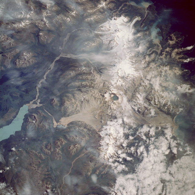 |
| STS028-90-13 Katmai National Monument, Alaska, U.S.A. August 1989 The second-largest unit of the U.S. National Park System (Yellowstone is the largest), Katmai National Monument and the Valley of Ten Thousand Smokes can be seen in this east-northeast-looking, low-oblique photograph. Located near the northern end of the Alaskan Peninsula, Katmai sits in a presently dormant volcanic region. In 1912, this region was the site of one of the greatest eruptions in recent history. As lava beneath Mount Katmai drained to the west, Novarupta Volcano erupted and then collapsed, forming a huge crater 8 miles (13 kilometers) in circumference and 3700 feet (1129 meters) deep (near the center of the photograph), which formed a lake. The explosion of Novarupta caused 40 square miles (100 square kilometers) of terrain around the volcano to be covered in ash and pumice as deep as 300 feet (90 meters). The Valley of Ten Thousand Smokes to the north-northwest of Novarupta Volcano [72 square miles (187 square kilometers)] had countless holes and cracks (fumeroles) on the surface, through which scalding hot gases (steam) passed to the surface--hence the valley's name. Today, all but a few of these volcanoes are extinct. Scars or deposits of ash and pumice (grayish-color) from the eruption can still be seen north and south of the water-filled crater. Plants have begun to colonize some portions of the valley. The light blue waters of Naknek Lake can be seen northwest of the Novarupta Crater. |
| Images: | All Available Images Low-Resolution 337k |
|
| Mission: | STS028 |
|
| Roll - Frame: | 90 - 13 |
|
| Geographical Name: | USA-ALASKA |
|
| Features: | ALEUTIAN RANGE |
|
| Center Lat x Lon: | 58.5N x 155W |
|
| Film Exposure: | N | N=Normal exposure, U=Under exposed, O=Over exposed, F=out of Focus |
| Percentage of Cloud Cover-CLDP: | 20 |
|
| Camera:: | HB |
|
| Camera Tilt: | 54 | LO=Low Oblique, HO=High Oblique, NV=Near Vertical |
| Camera Focal Length: | 250 |
|
| Nadir to Photo Center Direction: | E | The direction from the nadir to the center point, N=North, S=South, E=East, W=West |
| Stereo?: | N | Y=Yes there is an adjacent picture of the same area, N=No there isn't |
| Orbit Number: | 70 |
|
| Date: | 19890812 | YYYYMMDD |
| Time: | 210208 | GMT HHMMSS |
| Nadir Lat: | 57.1N |
Latitude of suborbital point of spacecraft |
| Nadir Lon: | 158.4W |
Longitude of suborbital point of spacecraft |
| Sun Azimuth: | 147 | Clockwise angle in degrees from north to the sun measured at the nadir point |
| Space Craft Altitude: | 161 | nautical miles |
| Sun Elevation: | 44 | Angle in degrees between the horizon and the sun, measured at the nadir point |
| Land Views: | MOUNTAIN, VOLCANO, VALLEY, GLACIER, COAST |
|
| Water Views: | RIVER, LAKE, SEDIMENT |
|
| Atmosphere Views: | |
|
| Man Made Views: | |
|
| City Views: | |
|
Photo is not associated with any sequences | ||
| NASA Home Page |
JSC Home Page |
JSC Digital Image Collection |
Earth Science & Remote Sensing |
|
This service is provided by the International Space Station program and the JSC Earth Science & Remote Sensing Unit, ARES Division, Exploration Integration Science Directorate.

|