Geographic Region: SPAIN
Feature: ROTA, CADIZ
|
Geographic Region: SPAIN Feature: ROTA, CADIZ |
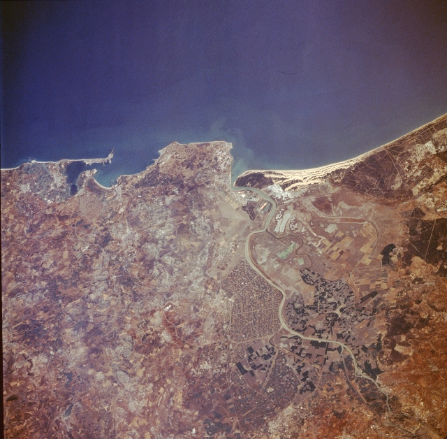 |
| STS028-074-078 Cadiz, Spain August 1989 This photograph shows approximately 60 miles (90 kilometers) of the southwest coast of Spain that fronts the Gulf of Cadiz. Several natural and manmade features are visible when viewing from south to north--the city of Cadiz, a seaport city with a population of approximately 180 000, located at the tip of a very narrow peninsula and surrounded by the Bay of Cadiz; the large runway of Rota Airport near the southern edge of the large angular peninsula, which protrudes into the Gulf of Cadiz; the mouth of the Guadalquivir River by which the city of Seville can be reached by small steamers; and a series of parallel, highly reflective sand dunes north of the mouth of the Guadalquivir River. Inland from the coast, cultivated field patterns are observed. Apparently a substantial amount of the former swampy area along the Guadalquivir River has been converted into productive irrigated farmland, and many canals have been constructed to maximize the available waterflow. |
| Images: | All Available Images Low-Resolution 358k |
|
| Mission: | STS028 |
|
| Roll - Frame: | 74 - 78 |
|
| Geographical Name: | SPAIN |
|
| Features: | ROTA, CADIZ |
|
| Center Lat x Lon: | 37.0N x 6W |
|
| Film Exposure: | N | N=Normal exposure, U=Under exposed, O=Over exposed, F=out of Focus |
| Percentage of Cloud Cover-CLDP: | 0 |
|
| Camera:: | HB |
|
| Camera Tilt: | 39 | LO=Low Oblique, HO=High Oblique, NV=Near Vertical |
| Camera Focal Length: | 250 |
|
| Nadir to Photo Center Direction: | SW | The direction from the nadir to the center point, N=North, S=South, E=East, W=West |
| Stereo?: | Y | Y=Yes there is an adjacent picture of the same area, N=No there isn't |
| Orbit Number: | 50 |
|
| Date: | 19890811 | YYYYMMDD |
| Time: | 150202 | GMT HHMMSS |
| Nadir Lat: | 38.8N |
Latitude of suborbital point of spacecraft |
| Nadir Lon: | 4.8W |
Longitude of suborbital point of spacecraft |
| Sun Azimuth: | 247 | Clockwise angle in degrees from north to the sun measured at the nadir point |
| Space Craft Altitude: | 163 | nautical miles |
| Sun Elevation: | 48 | Angle in degrees between the horizon and the sun, measured at the nadir point |
| Land Views: | COAST, DUNE, PLAIN, PENINSULA |
|
| Water Views: | RIVER, BAY |
|
| Atmosphere Views: | |
|
| Man Made Views: | AGRICULTURE |
|
| City Views: | |
|
Photo is not associated with any sequences | ||
| NASA Home Page |
JSC Home Page |
JSC Digital Image Collection |
Earth Science & Remote Sensing |
|
This service is provided by the International Space Station program and the JSC Earth Science & Remote Sensing Unit, ARES Division, Exploration Integration Science Directorate.

|