
Geographic Region: CANADA-BC
Feature: VANCOUVER
|
Geographic Region: CANADA-BC Feature: VANCOUVER |
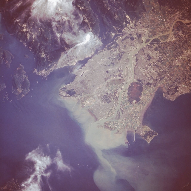 |
| STS028-072-044 Vancouver, British Columbia, Canada August 1989 The dynamic infrastructure of the industrial and economic center for British Columbia, the port city of Vancouver, with more than 1.6 million residents, is revealed in this closeup photograph. The Fraser River produces two peninsulas and two large islands that comprise the greater Vancouver metropolitan area. The northern peninsula shows the dense grid street pattern that constitutes the downtown commercial district and surrounding residential areas. Vancouver International Airport is located on Sea Island, the small island south of downtown. Lulu Island (Richmond area), the largest island, has a dense residential and commercial area along the coast, and large cultivated fields are found toward the eastern part of the island. Toward the end of the large peninsula south of Lulu Island, generally known as the Delta area, is an undeveloped, heavily vegetated area (dark area). Large cultivated field patterns and the dark, undeveloped area jutting out from the southwest coast of the Delta are two linear manmade features--the north facility is a superport terminal for oceangoing vessels, and the south facility is a ferry terminal for the numerous ferries linking the mainland with Vancouver Island and the Gulf Islands. The 49th parallel, the United States-Canada border, bisects the smaller peninsula south of the ferry terminals; the southern half of the peninsula actually belongs to the United States. (Refer to STS-028-071-016 for a synoptic view of the physical setting of the greater Vancouver area.) |
| Images: | All Available Images Low-Resolution 317k |
|
| Mission: | STS028 |
|
| Roll - Frame: | 72 - 44 |
|
| Geographical Name: | CANADA-BC |
|
| Features: | VANCOUVER |
|
| Center Lat x Lon: | 49.0N x 123W |
|
| Film Exposure: | N | N=Normal exposure, U=Under exposed, O=Over exposed, F=out of Focus |
| Percentage of Cloud Cover-CLDP: | 10 |
|
| Camera:: | HB |
|
| Camera Tilt: | 9 | LO=Low Oblique, HO=High Oblique, NV=Near Vertical |
| Camera Focal Length: | 250 |
|
| Nadir to Photo Center Direction: | SE | The direction from the nadir to the center point, N=North, S=South, E=East, W=West |
| Stereo?: | Y | Y=Yes there is an adjacent picture of the same area, N=No there isn't |
| Orbit Number: | 4 |
|
| Date: | 19890808 | YYYYMMDD |
| Time: | 172050 | GMT HHMMSS |
| Nadir Lat: | 49.3N |
Latitude of suborbital point of spacecraft |
| Nadir Lon: | 123.3W |
Longitude of suborbital point of spacecraft |
| Sun Azimuth: | 117 | Clockwise angle in degrees from north to the sun measured at the nadir point |
| Space Craft Altitude: | 161 | nautical miles |
| Sun Elevation: | 41 | Angle in degrees between the horizon and the sun, measured at the nadir point |
| Land Views: | MOUNTAIN, HILL, PENINSULA |
|
| Water Views: | RIVER, DELTA, SEDIMENT |
|
| Atmosphere Views: | |
|
| Man Made Views: | URBAN AREA, AIRPORT, AGRICULTURE |
|
| City Views: | VANCOUVER |
|
Photo is not associated with any sequences | ||
| NASA Home Page |
JSC Home Page |
JSC Digital Image Collection |
Earth Science & Remote Sensing |
|
This service is provided by the International Space Station program and the JSC Earth Science & Remote Sensing Unit, ARES Division, Exploration Integration Science Directorate.

|