
Geographic Region: USA-NEBRASKA
Feature: PLATTE RIVER
|
Geographic Region: USA-NEBRASKA Feature: PLATTE RIVER |
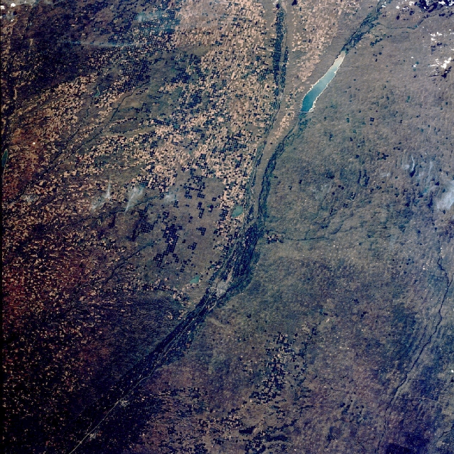 |
| STS028-071-089 North and South Platte Rivers, Nebraska, U.S.A. August 1989 The confluence of two rivers in west-central Nebraska, the North Platte and the South Platte, is revealed near the center of this west-looking, low-oblique photograph. Lake McConaughy on the North Platte River is seen near the northwest corner of the photograph. The river is 680 miles (1095 kilometers) long and originates in the Park Range of northern Colorado. Its waters are used for crop irrigation and grazing livestock in the area from near Guernsey, Wyoming, to below Bridgeport, Nebraska. North of Lake McConaughy and the North Platte River are the Nebraska Sand Hills (visible in the photograph), a maze of grass-covered dunes formed during the last glacial epoch. The South Platte River originates in the Rocky Mountains of Colorado northwest of Denver. After leaving the mountains and reaching the Great Plains, the river becomes a broad, shallow stream. It supplies water for cattle grazing and irrigation of agricultural crops (irrigated field patterns lie south of the river in the photograph). At the confluence of the two rivers near the city of North Platte, the river becomes the Platte and flows eastward 310 miles (500 kilometers) before joining the Missouri River south of Omaha. Much of the Platte River is used for irrigation and the production of hydroelectric power. |
| Images: | All Available Images Low-Resolution 444k |
|
| Mission: | STS028 |
|
| Roll - Frame: | 71 - 89 |
|
| Geographical Name: | USA-NEBRASKA |
|
| Features: | PLATTE RIVER |
|
| Center Lat x Lon: | 41.0N x 101W |
|
| Film Exposure: | N | N=Normal exposure, U=Under exposed, O=Over exposed, F=out of Focus |
| Percentage of Cloud Cover-CLDP: | 5 |
|
| Camera:: | HB |
|
| Camera Tilt: | 23 | LO=Low Oblique, HO=High Oblique, NV=Near Vertical |
| Camera Focal Length: | 100 |
|
| Nadir to Photo Center Direction: | SW | The direction from the nadir to the center point, N=North, S=South, E=East, W=West |
| Stereo?: | Y | Y=Yes there is an adjacent picture of the same area, N=No there isn't |
| Orbit Number: | 7 |
|
| Date: | 19890808 | YYYYMMDD |
| Time: | 220820 | GMT HHMMSS |
| Nadir Lat: | 42.0N |
Latitude of suborbital point of spacecraft |
| Nadir Lon: | 100.4W |
Longitude of suborbital point of spacecraft |
| Sun Azimuth: | 255 | Clockwise angle in degrees from north to the sun measured at the nadir point |
| Space Craft Altitude: | 163 | nautical miles |
| Sun Elevation: | 40 | Angle in degrees between the horizon and the sun, measured at the nadir point |
| Land Views: | PLAIN, HILL, VALLEY |
|
| Water Views: | RIVER, RESERVOIR |
|
| Atmosphere Views: | |
|
| Man Made Views: | AGRICULTURE, PIVOT IRRIGATION, DAM |
|
| City Views: | |
|
Photo is not associated with any sequences | ||
| NASA Home Page |
JSC Home Page |
JSC Digital Image Collection |
Earth Science & Remote Sensing |
|
This service is provided by the International Space Station program and the JSC Earth Science & Remote Sensing Unit, ARES Division, Exploration Integration Science Directorate.

|