Geographic Region: BANGLADESH
Feature: GANGES RIVER DELTA
|
Geographic Region: BANGLADESH Feature: GANGES RIVER DELTA |
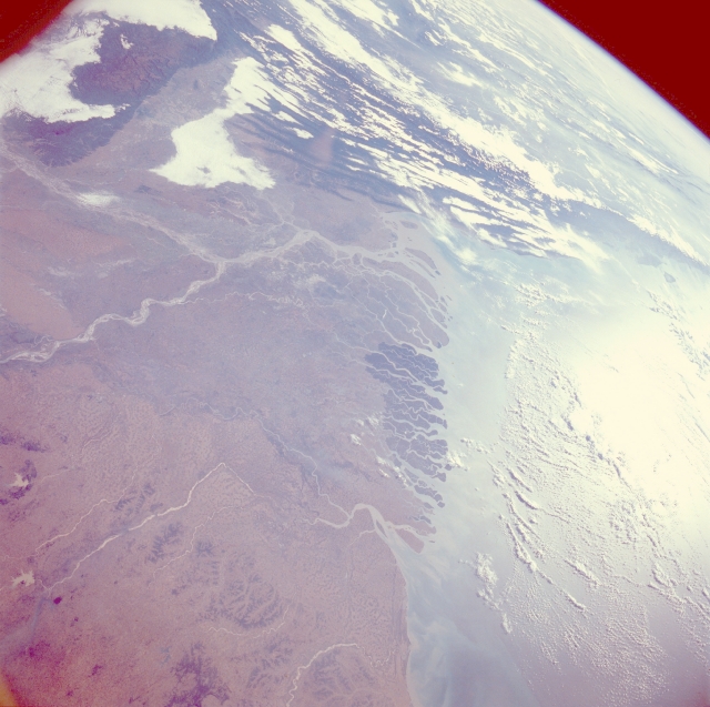 |
| STS027-39-28 Ganges-Brahmaputra River Delta, Bangladesh and India December 1988 The great Ganges-Brahmaputra River Delta of Bangladesh and India is the subject of this east-looking, oblique photograph. As the rivers empty, they carry large quantities of sediment into the Bay of Bengal. The delta (center of the photograph) is over 220 miles (350 kilometers) wide along the Bay of Bengal. The darker colored mangrove forests of the Sundarbans, a great wilderness of swamps, dense timber forests, small islands, and tidal creeks covering 6526 square miles (16 900 square kilometers), occupy the middle of the delta. The Sundarbans, a vast wildlife preserve, is one of the few remaining sanctuaries in India that is home of the world-famous Bengal tiger. The delta stretches from the Hooghly River in India (west of the Sundarbans) eastward to the Meghna River in Bangladesh. The Ganges, the most sacred river of Hindu India, can be seen in the photograph as it runs north of the Sundarbans, joining with the Brahmaputra River just west of Dacca (not distinguishable in the photograph). The dark, forested Khasi Hills are situated northeast of the convergence of the Ganges River and the Brahmaputra River. During the summer monsoon (late June through early October), tropical cyclones can form in the southern Bay of Bengal, proceed northward, and make landfall over the delta region, causing flooding, heavy damage to crops and shelters, and loss of human life. |
| Images: | All Available Images Low-Resolution 300k |
|
| Mission: | STS027 |
|
| Roll - Frame: | 39 - 28 |
|
| Geographical Name: | BANGLADESH |
|
| Features: | GANGES RIVER DELTA |
|
| Center Lat x Lon: | 22.5N x 90.5E |
|
| Film Exposure: | N | N=Normal exposure, U=Under exposed, O=Over exposed, F=out of Focus |
| Percentage of Cloud Cover-CLDP: | 30 |
|
| Camera:: | HB |
|
| Camera Tilt: | HO | LO=Low Oblique, HO=High Oblique, NV=Near Vertical |
| Camera Focal Length: | 250 |
|
| Nadir to Photo Center Direction: | E | The direction from the nadir to the center point, N=North, S=South, E=East, W=West |
| Stereo?: | N | Y=Yes there is an adjacent picture of the same area, N=No there isn't |
| Orbit Number: | 9 |
|
| Date: | 19881203 | YYYYMMDD |
| Time: | 030119 | GMT HHMMSS |
| Nadir Lat: | 23.5N |
Latitude of suborbital point of spacecraft |
| Nadir Lon: | 86.1E |
Longitude of suborbital point of spacecraft |
| Sun Azimuth: | 132 | Clockwise angle in degrees from north to the sun measured at the nadir point |
| Space Craft Altitude: | 241 | nautical miles |
| Sun Elevation: | 26 | Angle in degrees between the horizon and the sun, measured at the nadir point |
| Land Views: | PLAIN, COAST, HILL |
|
| Water Views: | RIVER, DELTA, BAY, SWAMP, SEDIMENT |
|
| Atmosphere Views: | |
|
| Man Made Views: | |
|
| City Views: | |
|
Photo is not associated with any sequences | ||
| NASA Home Page |
JSC Home Page |
JSC Digital Image Collection |
Earth Science & Remote Sensing |
|
This service is provided by the International Space Station program and the JSC Earth Science & Remote Sensing Unit, ARES Division, Exploration Integration Science Directorate.

|