Geographic Region: USA-TEXAS
Feature: CORPUS CHRISTI
|
Geographic Region: USA-TEXAS Feature: CORPUS CHRISTI |
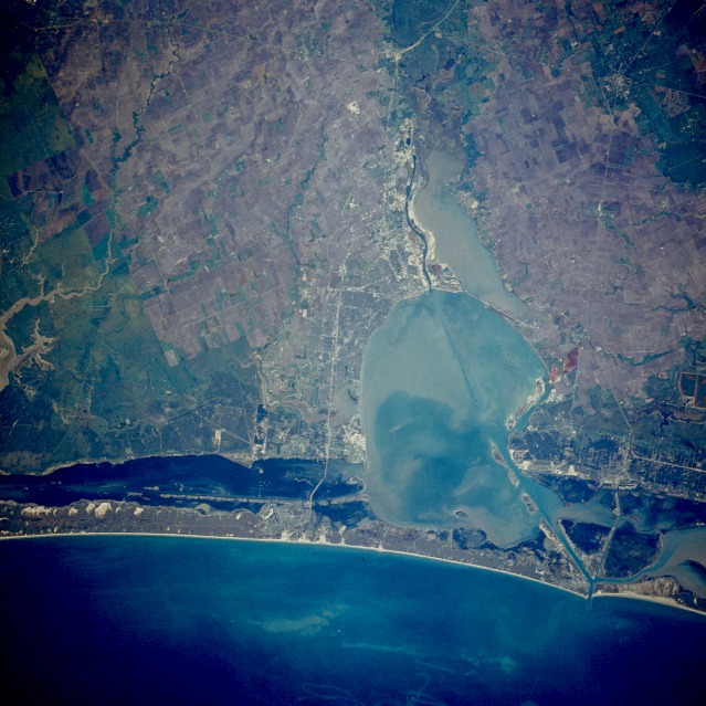 |
| STS026-044-038 Corpus Christi, Texas, U.S.A. September 1988 The city of Corpus Christi lies on the Texas coast along the sediment-laden bay of the same name. Corpus Christi, with a population of more than 235 000, is a major petroleum and natural gas production center. Heavy industry abounds in the area, with oil refineries, smelting plants, chemical works, and food processing establishments scattered throughout the city and its outlying regions. The city also supports a major fishing industry. Tourist and recreational resorts have become a major business on North Padre Island, east of the city on the Gulf of Mexico. Padre Island, which begins north of Corpus Christi near Port Aransas and parallels the Texas coast southward to near the United States-Mexico border, is the longest barrier island in the United States. Agricultural field patterns are visible west and northwest of Corpus Christi. West of the city, the Nueces River enters Nueces Bay, which, in turn, empties into Corpus Christi Bay. A dredged shipping channel is visible (dark turquoise water) traversing Corpus Christi Bay to its mouth near Port Aransas. Interstate Highway 37 can be seen running through Corpus Christi, crossing Laguna Madre, and terminating on North Padre Island. |
| Images: | All Available Images Low-Resolution 137k |
|
| Mission: | STS026 |
|
| Roll - Frame: | 44 - 38 |
|
| Geographical Name: | USA-TEXAS |
|
| Features: | CORPUS CHRISTI |
|
| Center Lat x Lon: | 27.5N x 97.5W |
|
| Film Exposure: | N | N=Normal exposure, U=Under exposed, O=Over exposed, F=out of Focus |
| Percentage of Cloud Cover-CLDP: | 0 |
|
| Camera:: | HB |
|
| Camera Tilt: | NV | LO=Low Oblique, HO=High Oblique, NV=Near Vertical |
| Camera Focal Length: | 250 |
|
| Nadir to Photo Center Direction: | The direction from the nadir to the center point, N=North, S=South, E=East, W=West |
|
| Stereo?: | Y | Y=Yes there is an adjacent picture of the same area, N=No there isn't |
| Orbit Number: | 48 |
|
| Date: | 1988____ | YYYYMMDD |
| Time: | GMT HHMMSS |
|
| Nadir Lat: | N |
Latitude of suborbital point of spacecraft |
| Nadir Lon: | E |
Longitude of suborbital point of spacecraft |
| Sun Azimuth: | Clockwise angle in degrees from north to the sun measured at the nadir point |
|
| Space Craft Altitude: | nautical miles |
|
| Sun Elevation: | Angle in degrees between the horizon and the sun, measured at the nadir point |
|
| Land Views: | COAST, ISLAND |
|
| Water Views: | BAY, CHANNEL, INLET, GULF, SEDIMENT |
|
| Atmosphere Views: | |
|
| Man Made Views: | URBAN AREA, AIRPORT, AGRICULTURE |
|
| City Views: | CORPUS CHRISTI |
|
Photo is not associated with any sequences | ||
| NASA Home Page |
JSC Home Page |
JSC Digital Image Collection |
Earth Science & Remote Sensing |
|
This service is provided by the International Space Station program and the JSC Earth Science & Remote Sensing Unit, ARES Division, Exploration Integration Science Directorate.

|