Geographic Region: INDONESIA
Feature: ILI BOLENG VOLCANO PLUME
|
Geographic Region: INDONESIA Feature: ILI BOLENG VOLCANO PLUME |
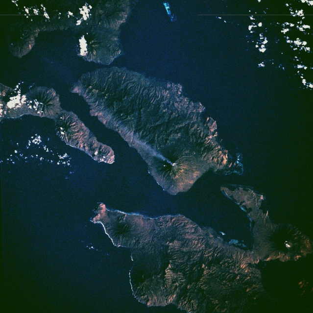 |
| STS008-50-1840 Adonara Island, Indonesia September 1983 The eruption plume from Ili Boleng, a stratovolcano on Adonara Island in the Lesser Sunda Islands, drifts from east to west in this near-vertical photograph. Ili Boleng has erupted many times since 1885. The 1973 eruption caused a large mudflow that swept down the mountainside, destroying a number of small villages and resulting in many fatalities. The other islands in this photograph are also characterized by active volcanoes with sometimes violent, explosive eruptions and frequent earthquakes that destroy life and property. Adonara Island covers 224 square miles (580 square kilometers) and is 23 miles (37 kilometers) long and 11 miles (18 kilometers) wide. Lomblen Island, with its many volcanoes, is east-southeast of Adonara Island. To Adonara's west, the eastern tip of Flores Island is visible; almost due south of Adonara is Solor Island. As part of Indonesia, a country that has more active volcanoes and more eruption fatalities than any country on Earth, Adonara Island lies in a subduction zone, where the Australian crustal plate dives beneath the Eurasian plate, forming an island arc volcanic system. |
| Images: | All Available Images Low-Resolution 345k |
|
| Mission: | STS008 |
|
| Roll - Frame: | 50 - 1840 |
|
| Geographical Name: | INDONESIA |
|
| Features: | ILI BOLENG VOLCANO PLUME |
|
| Center Lat x Lon: | 8.5S x 123.0E |
|
| Film Exposure: | U | N=Normal exposure, U=Under exposed, O=Over exposed, F=out of Focus |
| Percentage of Cloud Cover-CLDP: | 5 |
|
| Camera:: | HB |
|
| Camera Tilt: | NV | LO=Low Oblique, HO=High Oblique, NV=Near Vertical |
| Camera Focal Length: | 250 |
|
| Nadir to Photo Center Direction: | The direction from the nadir to the center point, N=North, S=South, E=East, W=West |
|
| Stereo?: | Y | Y=Yes there is an adjacent picture of the same area, N=No there isn't |
| Orbit Number: | 12 |
|
| Date: | 1983____ | YYYYMMDD |
| Time: | GMT HHMMSS |
|
| Nadir Lat: | N |
Latitude of suborbital point of spacecraft |
| Nadir Lon: | E |
Longitude of suborbital point of spacecraft |
| Sun Azimuth: | Clockwise angle in degrees from north to the sun measured at the nadir point |
|
| Space Craft Altitude: | nautical miles |
|
| Sun Elevation: | Angle in degrees between the horizon and the sun, measured at the nadir point |
|
| Land Views: | VOLCANO, CRATER, MOUNTAIN, COAST, ISLAND |
|
| Water Views: | SEA |
|
| Atmosphere Views: | |
|
| Man Made Views: | |
|
| City Views: | |
|
Photo is not associated with any sequences | ||
| NASA Home Page |
JSC Home Page |
JSC Digital Image Collection |
Earth Science & Remote Sensing |
|
This service is provided by the International Space Station program and the JSC Earth Science & Remote Sensing Unit, ARES Division, Exploration Integration Science Directorate.

|