Geographic Region: UK-ENGLAND
Feature: WIGHT ISLAND
|
Geographic Region: UK-ENGLAND Feature: WIGHT ISLAND |
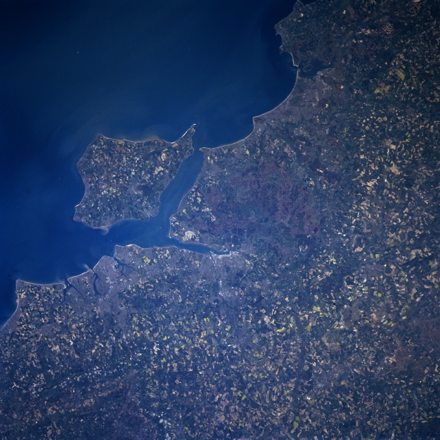 |
| NM23-762-210 Isle of Wight, South Downs, Portsmouth, Great Britain Winter/Spring 1997 The south central coast of England and the Isle of Wight can be seen in this south-southwest-looking view. Situated on the image midway between the center and left center, the Isle of Wight is 23 miles (37km) long and 13 miles (21 km) wide and covers an area of 147 sq. miles (381 sq. km). The Solent and Spithead Channels separate the Isle of Wight from southern England. The mild climate, scenery, and beautiful coastline make the Isle of Wight a popular tourist resort. In the bottom left quadrant of the image and extending to near the center of the image, the parallel ranges of the South Downs and Chalk Hills, are visible. Along the coast just to the north of the Isle of Wight, is the city of Portsmouth. The city is the site of a major British naval base. Portsmouth is the birthplace of noted author Charles Dickens. Another port and ship building city, Southampton, can be identified at the northern end of the elongated estuary north of Solent Channel. |
| Images: | All Available Images Low-Resolution 361k |
|
| Mission: | NM23 |
|
| Roll - Frame: | 762 - 210 |
|
| Geographical Name: | UK-ENGLAND |
|
| Features: | WIGHT ISLAND |
|
| Center Lat x Lon: | 51.0N x 1W |
|
| Film Exposure: | N | N=Normal exposure, U=Under exposed, O=Over exposed, F=out of Focus |
| Percentage of Cloud Cover-CLDP: | 0 |
|
| Camera:: | HB |
|
| Camera Tilt: | 45 | LO=Low Oblique, HO=High Oblique, NV=Near Vertical |
| Camera Focal Length: | 100 |
|
| Nadir to Photo Center Direction: | W | The direction from the nadir to the center point, N=North, S=South, E=East, W=West |
| Stereo?: | Y | Y=Yes there is an adjacent picture of the same area, N=No there isn't |
| Orbit Number: | 999 |
|
| Date: | 19970502 | YYYYMMDD |
| Time: | 133609 | GMT HHMMSS |
| Nadir Lat: | 49.7N |
Latitude of suborbital point of spacecraft |
| Nadir Lon: | 2.2E |
Longitude of suborbital point of spacecraft |
| Sun Azimuth: | 222 | Clockwise angle in degrees from north to the sun measured at the nadir point |
| Space Craft Altitude: | 210 | nautical miles |
| Sun Elevation: | 50 | Angle in degrees between the horizon and the sun, measured at the nadir point |
| Land Views: | COAST, ISLAND, PLAIN , UPLAND |
|
| Water Views: | SEA, STRAIT, RIVER |
|
| Atmosphere Views: | |
|
| Man Made Views: | URBAN AREA, AGRICULTURE |
|
| City Views: | |
|
Photo is not associated with any sequences | ||
| NASA Home Page |
JSC Home Page |
JSC Digital Image Collection |
Earth Science & Remote Sensing |
|
This service is provided by the International Space Station program and the JSC Earth Science & Remote Sensing Unit, ARES Division, Exploration Integration Science Directorate.

|