Geographic Region: IRELAND
Feature: LAKE NEAGH
|
Geographic Region: IRELAND Feature: LAKE NEAGH |
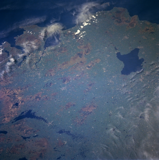 |
| NM23-762-198 Lakes Erne and Neagh, Great Britain Winter/Spring 1997 Most of the area, except of the far eastern portion, of Northern Ireland can be seen in this northeast-looking view. Most notable in this view are two large lakes. Near the right center of the image is Lake Neagh, the largest freshwater lake in the British Isles. The lake is 18 miles (29 km) long and 11 miles (18km) wide and covers an area of 153 sq. miles (396 sq. km). Lake Neagh is not a deep lake, but it is noted for its pollan, trout, and eel fisheries. Mesolithic man is believed by archeologists to have first appeared here in Ireland near the lake around 6000 B.C. In the lower left portion of the image, the semi-circular shaped Lake Erne is visible. Lake Erne is 18 miles (29 km) long. In the upper left corner of the image and discernible under wispy high cirrus clouds is Malin Head, the northernmost point of the country of Ireland. |
| Images: | All Available Images Low-Resolution 333k |
|
| Mission: | NM23 |
|
| Roll - Frame: | 762 - 198 |
|
| Geographical Name: | IRELAND |
|
| Features: | LAKE NEAGH |
|
| Center Lat x Lon: | 54.5N x 7.5W |
|
| Film Exposure: | N | N=Normal exposure, U=Under exposed, O=Over exposed, F=out of Focus |
| Percentage of Cloud Cover-CLDP: | 10 |
|
| Camera:: | HB |
|
| Camera Tilt: | LO | LO=Low Oblique, HO=High Oblique, NV=Near Vertical |
| Camera Focal Length: | 100 |
|
| Nadir to Photo Center Direction: | NW | The direction from the nadir to the center point, N=North, S=South, E=East, W=West |
| Stereo?: | Y | Y=Yes there is an adjacent picture of the same area, N=No there isn't |
| Orbit Number: | 999 |
|
| Date: | 19970502 | YYYYMMDD |
| Time: | 133519 | GMT HHMMSS |
| Nadir Lat: | 50.6N |
Latitude of suborbital point of spacecraft |
| Nadir Lon: | 2.5W |
Longitude of suborbital point of spacecraft |
| Sun Azimuth: | 215 | Clockwise angle in degrees from north to the sun measured at the nadir point |
| Space Craft Altitude: | 209 | nautical miles |
| Sun Elevation: | 51 | Angle in degrees between the horizon and the sun, measured at the nadir point |
| Land Views: | COAST, UPLAND, HILL |
|
| Water Views: | LAKE |
|
| Atmosphere Views: | |
|
| Man Made Views: | |
|
| City Views: | |
|
Photo is not associated with any sequences | ||
| NASA Home Page |
JSC Home Page |
JSC Digital Image Collection |
Earth Science & Remote Sensing |
|
This service is provided by the International Space Station program and the JSC Earth Science & Remote Sensing Unit, ARES Division, Exploration Integration Science Directorate.

|