
Geographic Region: USA-NEW MEXICO
Feature: WHITE SANDS
|
Geographic Region: USA-NEW MEXICO Feature: WHITE SANDS |
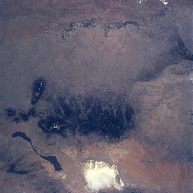 |
| NM23-761-679 Sacramento Mountains, New Mexico, USA Winter-Spring 1997 The forested slopes of the Sacramento Mountains (large dark feature near center of the image) contrast against an otherwise arid environment (lighter colored terrain). The highly reflective White Sands National Monument, located in the Tularosa Valley is visible west of the Sacramento Mountains. The elongated, ribbon-like, dark feature northwest of the Sacramento Mountains is a basaltic lava flow that originated from a vent at the northern end of the valley. Two other mountain ranges, Capitan and Guadalupe, can be identified north, and southeast, respectively, of the Sacramento Mountains. The mottled looking landscape (north-south swath) towards the eastern edge of the image is the irrigated agriculture of the Pecos River Valley, where artesian wells are used to provide water. The main channel of the intermittently flowing Rio Hondo and many of its tributaries can be traced from the northeast slopes of the Sacramento Mountains to the point where the Rio Hondo merges with the Pecos River at the town of Roswell (barely discernible). |
| Images: | All Available Images Low-Resolution 318k |
|
| Mission: | NM23 |
|
| Roll - Frame: | 761 - 679 |
|
| Geographical Name: | USA-NEW MEXICO |
|
| Features: | WHITE SANDS |
|
| Center Lat x Lon: | 33.0N x 105.5W |
|
| Film Exposure: | N | N=Normal exposure, U=Under exposed, O=Over exposed, F=out of Focus |
| Percentage of Cloud Cover-CLDP: | 0 |
|
| Camera:: | HB |
|
| Camera Tilt: | LO | LO=Low Oblique, HO=High Oblique, NV=Near Vertical |
| Camera Focal Length: | 100 |
|
| Nadir to Photo Center Direction: | SE | The direction from the nadir to the center point, N=North, S=South, E=East, W=West |
| Stereo?: | Y | Y=Yes there is an adjacent picture of the same area, N=No there isn't |
| Orbit Number: | 999 |
|
| Date: | 19970503 | YYYYMMDD |
| Time: | 153043 | GMT HHMMSS |
| Nadir Lat: | 35.8N |
Latitude of suborbital point of spacecraft |
| Nadir Lon: | 110.1W |
Longitude of suborbital point of spacecraft |
| Sun Azimuth: | 96 | Clockwise angle in degrees from north to the sun measured at the nadir point |
| Space Craft Altitude: | 207 | nautical miles |
| Sun Elevation: | 36 | Angle in degrees between the horizon and the sun, measured at the nadir point |
| Land Views: | MOUNTAIN, DUNE, BASIN |
|
| Water Views: | RIVER |
|
| Atmosphere Views: | |
|
| Man Made Views: | |
|
| City Views: | |
|
Photo is not associated with any sequences | ||
| NASA Home Page |
JSC Home Page |
JSC Digital Image Collection |
Earth Science & Remote Sensing |
|
This service is provided by the International Space Station program and the JSC Earth Science & Remote Sensing Unit, ARES Division, Exploration Integration Science Directorate.

|