Geographic Region: CANADA-N
Feature: AVALON PENINSULA
|
Geographic Region: CANADA-N Feature: AVALON PENINSULA |
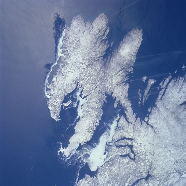 |
| NM23-759-564 Avalon Peninsula, Newfoundland, Canada Winter 1997 The snow and ice covered coastline of southeastern Newfoundland, including the Avalon Peninsula, is visible in this western view of this island province of Canada. Sea ice is identified as the uniform-looking, whiter areas with a swirling pattern, especially evident in Trinity and Conception Bays along the north coast of the Avalon Peninsula. The two southern bays of Placenta and Saint Mary's do not show any sea ice; however, there is some ice visible along the east coast. Notice the snow and ice cover on the land looks different from the sea ice because snow accentuates some relief and contour details of the topography. The elongated, linear, light-colored "streaks" that are aligned in a general west-east orientation are aircraft contrails of jets flying from North America to Europe. |
| Images: | All Available Images Low-Resolution 318k |
|
| Mission: | NM23 |
|
| Roll - Frame: | 759 - 564 |
|
| Geographical Name: | CANADA-N |
|
| Features: | AVALON PENINSULA |
|
| Center Lat x Lon: | 47.5N x 53W |
|
| Film Exposure: | N | N=Normal exposure, U=Under exposed, O=Over exposed, F=out of Focus |
| Percentage of Cloud Cover-CLDP: | 0 |
|
| Camera:: | HB |
|
| Camera Tilt: | LO | LO=Low Oblique, HO=High Oblique, NV=Near Vertical |
| Camera Focal Length: | 100 |
|
| Nadir to Photo Center Direction: | W | The direction from the nadir to the center point, N=North, S=South, E=East, W=West |
| Stereo?: | Y | Y=Yes there is an adjacent picture of the same area, N=No there isn't |
| Orbit Number: | 999 |
|
| Date: | 19970501 | YYYYMMDD |
| Time: | 142439 | GMT HHMMSS |
| Nadir Lat: | 49.7N |
Latitude of suborbital point of spacecraft |
| Nadir Lon: | 48W |
Longitude of suborbital point of spacecraft |
| Sun Azimuth: | 161 | Clockwise angle in degrees from north to the sun measured at the nadir point |
| Space Craft Altitude: | 208 | nautical miles |
| Sun Elevation: | 55 | Angle in degrees between the horizon and the sun, measured at the nadir point |
| Land Views: | PENINSULA |
|
| Water Views: | SEA ICE, BAY |
|
| Atmosphere Views: | |
|
| Man Made Views: | |
|
| City Views: | |
|
Photo is not associated with any sequences | ||
| NASA Home Page |
JSC Home Page |
JSC Digital Image Collection |
Earth Science & Remote Sensing |
|
This service is provided by the International Space Station program and the JSC Earth Science & Remote Sensing Unit, ARES Division, Exploration Integration Science Directorate.

|