Geographic Region: UK-ENGLAND
Feature: THE WASH
|
Geographic Region: UK-ENGLAND Feature: THE WASH |
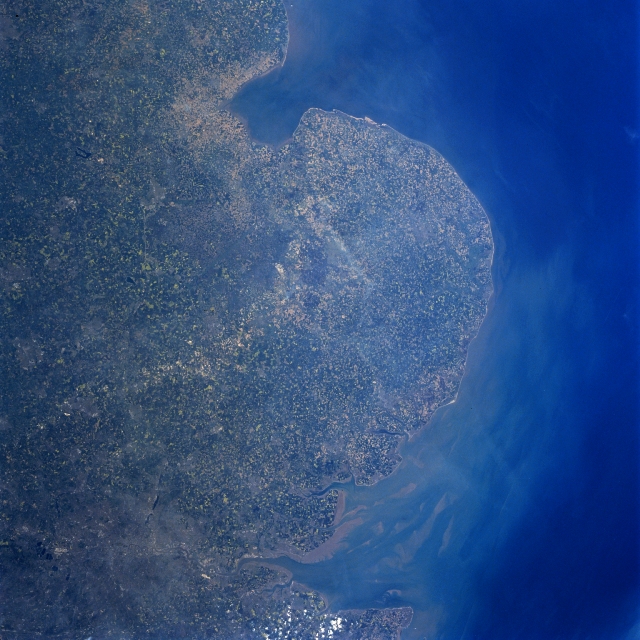 |
| NM23-758-653 The Fens, The Wash, North Sea, Great Britain Winter/Spring 1997 The field patterns of east central Great Britain are visible in this north-looking view. Near the top center of the image, The Wash, an inlet of the North Sea (upper middle) can be seen. The Wash is 20 miles (32 km) long and 15 miles (24 km) wide. It is shallow with sandbars and low, marshy shores. Dredged ship channels lead to the ports of Boston and King's Lynn (neither city is visible on the image). Just below The Wash near the center of the image is an area called The Fens, a flat lowland area. The Fens extends 70 miles (115 km) from north to south, and 35 miles (55 km) from east to west. Numerous streams traverse the region. The area was originally the largest swampland in Great Britain, formed by sediment from the North Sea. Although this region was initially unproductive land for agriculture, a successful drainage improvement project was completed in the 1960's. Since the successful completion of this project, cultivation of the land in The Fens has occurred. The location of London, England's largest city can be identified in the lower left corner of the image. The Thames River Delta and Estuary is also visible at the bottom center of the image. |
| Images: | All Available Images Low-Resolution 350k |
|
| Mission: | NM23 |
|
| Roll - Frame: | 758 - 653 |
|
| Geographical Name: | UK-ENGLAND |
|
| Features: | THE WASH |
|
| Center Lat x Lon: | 52.5N x 1.5E |
|
| Film Exposure: | N | N=Normal exposure, U=Under exposed, O=Over exposed, F=out of Focus |
| Percentage of Cloud Cover-CLDP: | 0 |
|
| Camera:: | HB |
|
| Camera Tilt: | LO | LO=Low Oblique, HO=High Oblique, NV=Near Vertical |
| Camera Focal Length: | 100 |
|
| Nadir to Photo Center Direction: | W | The direction from the nadir to the center point, N=North, S=South, E=East, W=West |
| Stereo?: | Y | Y=Yes there is an adjacent picture of the same area, N=No there isn't |
| Orbit Number: | |
|
| Date: | 19970503 | YYYYMMDD |
| Time: | GMT HHMMSS |
|
| Nadir Lat: | N |
Latitude of suborbital point of spacecraft |
| Nadir Lon: | E |
Longitude of suborbital point of spacecraft |
| Sun Azimuth: | Clockwise angle in degrees from north to the sun measured at the nadir point |
|
| Space Craft Altitude: | nautical miles |
|
| Sun Elevation: | Angle in degrees between the horizon and the sun, measured at the nadir point |
|
| Land Views: | PLAIN |
|
| Water Views: | BAY, ESTUARY, SEDIMENT |
|
| Atmosphere Views: | |
|
| Man Made Views: | AGRICULTURE, URBAN AREA |
|
| City Views: | |
|
Photo is not associated with any sequences | ||
| NASA Home Page |
JSC Home Page |
JSC Digital Image Collection |
Earth Science & Remote Sensing |
|
This service is provided by the International Space Station program and the JSC Earth Science & Remote Sensing Unit, ARES Division, Exploration Integration Science Directorate.

|