Geographic Region: UK-ENGLAND
Feature: BRISTOL CHANNEL
|
Geographic Region: UK-ENGLAND Feature: BRISTOL CHANNEL |
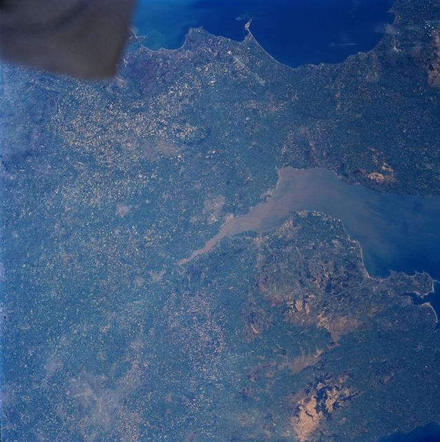 |
| NM23-758-643 Severn River, Bristol Channel, Great Britain Winter/Spring 1997 The Severn River, one of Great Britain's principal rivers, can be traced across the landscape as it empties into the eastern end of Bristol Channel. The river is an important transportation route in southwestern England. Bristol Channel (center to right center of the image), an inlet of the Atlantic Ocean, is 85 miles (135 km) long and 5 to 50 miles (8 to 81 km) wide. The Channel separates Wales (bottom portion) from Southwestern England (upper portion). Along the coast of southern Wales, there is a great concentration of economic activity (cities of Newport just to the right of center, and Cardiff just to the right of Newport). The city of Bristol in England is also an industrial center and is located slightly above the center of the image. The Bristol Channel serves as a major shipping corridor. The Cambrian Mountains, a rugged upland plateau that is cut by numerous river valleys, are visible in the right bottom portion of the image. Lymc Bay, an inlet of the English Channel, is seen along the south coast. A small section of the spacecraft is visible in the upper left corner of the image. |
| Images: | All Available Images Low-Resolution 375k |
|
| Mission: | NM23 |
|
| Roll - Frame: | 758 - 643 |
|
| Geographical Name: | UK-ENGLAND |
|
| Features: | BRISTOL CHANNEL |
|
| Center Lat x Lon: | 51.5N x 2.5W |
|
| Film Exposure: | N | N=Normal exposure, U=Under exposed, O=Over exposed, F=out of Focus |
| Percentage of Cloud Cover-CLDP: | 0 |
|
| Camera:: | HB |
|
| Camera Tilt: | LO | LO=Low Oblique, HO=High Oblique, NV=Near Vertical |
| Camera Focal Length: | 100 |
|
| Nadir to Photo Center Direction: | W | The direction from the nadir to the center point, N=North, S=South, E=East, W=West |
| Stereo?: | Y | Y=Yes there is an adjacent picture of the same area, N=No there isn't |
| Orbit Number: | |
|
| Date: | 19970503 | YYYYMMDD |
| Time: | GMT HHMMSS |
|
| Nadir Lat: | N |
Latitude of suborbital point of spacecraft |
| Nadir Lon: | E |
Longitude of suborbital point of spacecraft |
| Sun Azimuth: | Clockwise angle in degrees from north to the sun measured at the nadir point |
|
| Space Craft Altitude: | nautical miles |
|
| Sun Elevation: | Angle in degrees between the horizon and the sun, measured at the nadir point |
|
| Land Views: | PLAIN, HILL |
|
| Water Views: | RIVER, SEDIMENT |
|
| Atmosphere Views: | |
|
| Man Made Views: | AGRICULTURE |
|
| City Views: | |
|
Photo is not associated with any sequences | ||
| NASA Home Page |
JSC Home Page |
JSC Digital Image Collection |
Earth Science & Remote Sensing |
|
This service is provided by the International Space Station program and the JSC Earth Science & Remote Sensing Unit, ARES Division, Exploration Integration Science Directorate.

|