Geographic Region: SPAIN
Feature: GUADALQUIVIR RIVER DELTA
|
Geographic Region: SPAIN Feature: GUADALQUIVIR RIVER DELTA |
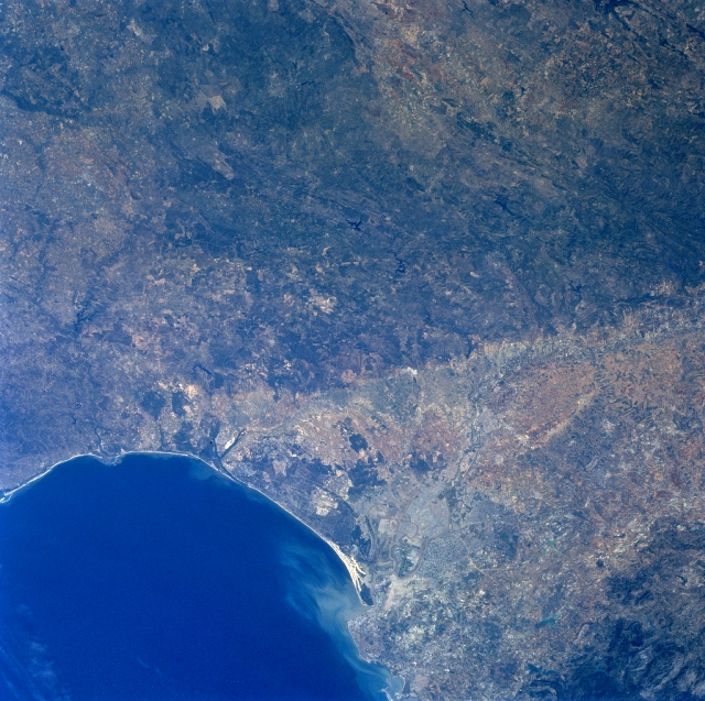 |
| NM23-757-024 Guadaluivir River, Spain Winter/Spring 1997 Geologically this image can be divided into an old massif (darker looking landscape--center top) and an extensive, wedge-shaped depression, alluvial plain (lighter colored region) that is located south of the low mountains. Faulting has produced the distinct and fairly abrupt color change between the two physiographic features. Faulting within the Morena Mountains, however, is generally aligned in a northwest-southeast orientation. The Guadalquivir River is visible as it meanders and flows in a westerly direction along the southern edge of the Morena Mountains in southwest Spain. The location of Spain's third largest city, Seville (estimated population 800000), is barely visible along the east bank of the Guadalquivir River, after the river takes a more southerly course towards the Gulf of Cadiz. The river mouth is visible by the light-colored sediment plume that is being dispersed northwestward along the coast. A sizable wildlife sanctuary and the Donana National Park with it's extensive beach area and moving sand dunes, as well as a marshy landscape inland from the coast is located immediately north of the mouth of the Guadalquivir River. An intricate network of irrigation canals is also discernible between Seville and the mouth of the river. |
| Images: | All Available Images Low-Resolution 380k |
|
| Mission: | NM23 |
|
| Roll - Frame: | 757 - 24 |
|
| Geographical Name: | SPAIN |
|
| Features: | GUADALQUIVIR RIVER DELTA |
|
| Center Lat x Lon: | 36.5N x 6.5W |
|
| Film Exposure: | N | N=Normal exposure, U=Under exposed, O=Over exposed, F=out of Focus |
| Percentage of Cloud Cover-CLDP: | 0 |
|
| Camera:: | HB |
|
| Camera Tilt: | LO | LO=Low Oblique, HO=High Oblique, NV=Near Vertical |
| Camera Focal Length: | 100 |
|
| Nadir to Photo Center Direction: | SW | The direction from the nadir to the center point, N=North, S=South, E=East, W=West |
| Stereo?: | Y | Y=Yes there is an adjacent picture of the same area, N=No there isn't |
| Orbit Number: | 999 |
|
| Date: | 19970501 | YYYYMMDD |
| Time: | 094240 | GMT HHMMSS |
| Nadir Lat: | 40.6N |
Latitude of suborbital point of spacecraft |
| Nadir Lon: | 1.7W |
Longitude of suborbital point of spacecraft |
| Sun Azimuth: | 119 | Clockwise angle in degrees from north to the sun measured at the nadir point |
| Space Craft Altitude: | 208 | nautical miles |
| Sun Elevation: | 50 | Angle in degrees between the horizon and the sun, measured at the nadir point |
| Land Views: | MOUNTAIN, FAULT, VALLEY |
|
| Water Views: | RIVER, SEDIMENT, GULF |
|
| Atmosphere Views: | |
|
| Man Made Views: | |
|
| City Views: | |
|
Photo is not associated with any sequences | ||
| NASA Home Page |
JSC Home Page |
JSC Digital Image Collection |
Earth Science & Remote Sensing |
|
This service is provided by the International Space Station program and the JSC Earth Science & Remote Sensing Unit, ARES Division, Exploration Integration Science Directorate.

|