Geographic Region: ISRAEL
Feature: JORDAN RIVER VALLEY, COAST
|
Geographic Region: ISRAEL Feature: JORDAN RIVER VALLEY, COAST |
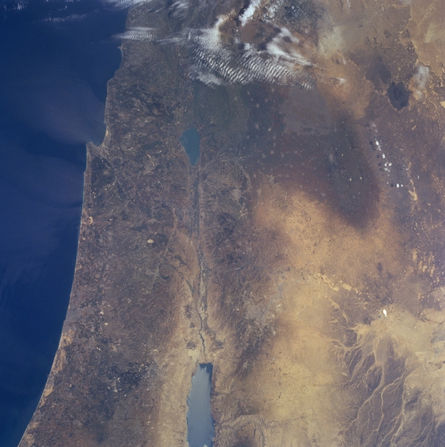 |
| NM23-755-505 Jordan River Valley, Israel Winter/Spring 1997 The rift valley of the Jordan River can be seen in this north-looking view. The country of Israel is to the left of the river valley and the country of Jordan is to the right of the river valley. The Jordan River is 200 miles (322 km) long and originates in the anti-Lebanon Mountains. The river flows southward through the drained Hula Valley Basin into the freshwater Lake Tiberias (Sea of Galilee) midway between the center and top center of the image. Lake Tiberias is 14 miles (22 km) long and up to 7 miles (11 km) wide, and covers an area of 64 square miles (165 sq km). The lake is 700 feet (215 meters) below sea level. The lake derives 75 percent of its inflow from the Jordan River. As the Jordan River exits Lake Tiberias and flows southward, its salinity increases as it reaches its terminus flowing into the Dead Sea. The Dead Sea (bottom center of the image) is 45 miles (70 km) long and presently is 1307 feet (399 meters) below sea level, the lowest point on earth. Demand for water from the Jordan River for irrigation since the 1970's, has reduced the flow of water into the Dead Sea, thus reducing the water level of the sea. The Jordan River Rift Valley is a small part of the 4037 mile (6500 km) long Syrian-East African Rift. |
| Images: | All Available Images Low-Resolution 309k |
|
| Mission: | NM23 |
|
| Roll - Frame: | 755 - 505 |
|
| Geographical Name: | ISRAEL |
|
| Features: | JORDAN RIVER VALLEY, COAST |
|
| Center Lat x Lon: | 32.0N x 35.5E |
|
| Film Exposure: | N | N=Normal exposure, U=Under exposed, O=Over exposed, F=out of Focus |
| Percentage of Cloud Cover-CLDP: | 5 |
|
| Camera:: | HB |
|
| Camera Tilt: | HO | LO=Low Oblique, HO=High Oblique, NV=Near Vertical |
| Camera Focal Length: | 100 |
|
| Nadir to Photo Center Direction: | SE | The direction from the nadir to the center point, N=North, S=South, E=East, W=West |
| Stereo?: | Y | Y=Yes there is an adjacent picture of the same area, N=No there isn't |
| Orbit Number: | 999 |
|
| Date: | 19970503 | YYYYMMDD |
| Time: | 061650 | GMT HHMMSS |
| Nadir Lat: | 35.4N |
Latitude of suborbital point of spacecraft |
| Nadir Lon: | 30.1E |
Longitude of suborbital point of spacecraft |
| Sun Azimuth: | 97 | Clockwise angle in degrees from north to the sun measured at the nadir point |
| Space Craft Altitude: | 207 | nautical miles |
| Sun Elevation: | 37 | Angle in degrees between the horizon and the sun, measured at the nadir point |
| Land Views: | RIFT, HILL, FAULT |
|
| Water Views: | LAKE, SEA, RIVER |
|
| Atmosphere Views: | |
|
| Man Made Views: | |
|
| City Views: | |
|
Photo is not associated with any sequences | ||
| NASA Home Page |
JSC Home Page |
JSC Digital Image Collection |
Earth Science & Remote Sensing |
|
This service is provided by the International Space Station program and the JSC Earth Science & Remote Sensing Unit, ARES Division, Exploration Integration Science Directorate.

|