Geographic Region: BAHAMAS
Feature: ELEUTHERA ISLAND
|
Geographic Region: BAHAMAS Feature: ELEUTHERA ISLAND |
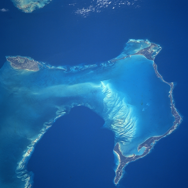 |
| NM23-739-100 New Providence and Eleuthera Islands, Bahamas Winter/Spring 1997 The Bahama Islands of New Providence (left center) and Eleuthera (right half) are visible in this north-northwest-looking view. New Providence Island, where the capital city of the Bahamas, Nassau is located, is 21 miles (34 km) long and 7 miles (11 km) wide and covers an area of 80 sq. miles (207 sq. km). Nassau is the commercial and social center of the Bahamas. The city has a large and beautiful harbor. Nassau has a warm, healthful climate, and a colorful atmosphere that makes the city a favorite winter resort. Eleuthera Island is 80 miles (133 km) long and 2 miles (3 km) wide, and covers an area of 164 sq. miles (425 sq. km). The island is generally flat and has no rivers. There are many mangrove swamps, brackish lakes, coral reefs and shoals, and miles (km) of fine sandy beaches. Eleuthera, which means "freedom" in Greek, was one of the first of the Bahama Islands to be colonized. The darker blue water of the Northeast Providence Channel (this is part of the Grand Bahama Submarine Canyon) is visible across the top portion of the image. The extreme southern portion of the Berry Islands, are discernible in the upper-left portion of the image. Covering the lower center portion of the image are the dark blue waters of Exuma Sound. |
| Images: | All Available Images Low-Resolution 277k |
|
| Mission: | NM23 |
|
| Roll - Frame: | 739 - 100 |
|
| Geographical Name: | BAHAMAS |
|
| Features: | ELEUTHERA ISLAND |
|
| Center Lat x Lon: | 25.0N x 76.5W |
|
| Film Exposure: | N | N=Normal exposure, U=Under exposed, O=Over exposed, F=out of Focus |
| Percentage of Cloud Cover-CLDP: | 0 |
|
| Camera:: | HB |
|
| Camera Tilt: | LO | LO=Low Oblique, HO=High Oblique, NV=Near Vertical |
| Camera Focal Length: | 250 |
|
| Nadir to Photo Center Direction: | W | The direction from the nadir to the center point, N=North, S=South, E=East, W=West |
| Stereo?: | Y | Y=Yes there is an adjacent picture of the same area, N=No there isn't |
| Orbit Number: | 999 |
|
| Date: | 19970418 | YYYYMMDD |
| Time: | 173437 | GMT HHMMSS |
| Nadir Lat: | 18.6N |
Latitude of suborbital point of spacecraft |
| Nadir Lon: | 78.6E |
Longitude of suborbital point of spacecraft |
| Sun Azimuth: | 328 | Clockwise angle in degrees from north to the sun measured at the nadir point |
| Space Craft Altitude: | 211 | nautical miles |
| Sun Elevation: | -56 | Angle in degrees between the horizon and the sun, measured at the nadir point |
| Land Views: | ISLAND |
|
| Water Views: | OCEAN, STRAIT |
|
| Atmosphere Views: | |
|
| Man Made Views: | URBAN AREA |
|
| City Views: | |
|
Photo is not associated with any sequences | ||
| NASA Home Page |
JSC Home Page |
JSC Digital Image Collection |
Earth Science & Remote Sensing |
|
This service is provided by the International Space Station program and the JSC Earth Science & Remote Sensing Unit, ARES Division, Exploration Integration Science Directorate.

|