Geographic Region: CHILE
Feature: MAULLIN BAY
|
Geographic Region: CHILE Feature: MAULLIN BAY |
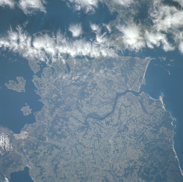 |
| NM23-720-597 Maullin River, Puerto Montt, Chile Winter/Spring 1997 The southern end of the Central Valley of Chile can be seen in this south-looking view. The southern portion of the large Lake Lianquihue is visible in the lower left of the image. The Maullin River flows generally southwestward, over a number of small waterfalls, emptying into the Gulf of Coranados at the center right of the image. Clouds cover the Chacao Channel that separates the southern end of Central Valley and the northern end of Chiloe Island, barely discernible through the clouds at the upper right of the image. The small city of Puerto Montt is visible 12 miles (18 km) south of Lake Lianquihue (lower left). Located at the northern end of the Gulf of Ancud, Puerto Montt is the terminus of the southern railroad and the starting point for navigation through the inland waterways and among the many islands to the south. The city is a popular tourist resort. Sheep farming and fishing are also important industries in the region. The Gulf of Ancud covers the left center and upper left of the image. |
| Images: | All Available Images Low-Resolution 332k |
|
| Mission: | NM23 |
|
| Roll - Frame: | 720 - 597 |
|
| Geographical Name: | CHILE |
|
| Features: | MAULLIN BAY |
|
| Center Lat x Lon: | 41.5S x 73.5W |
|
| Film Exposure: | N | N=Normal exposure, U=Under exposed, O=Over exposed, F=out of Focus |
| Percentage of Cloud Cover-CLDP: | 15 |
|
| Camera:: | HB |
|
| Camera Tilt: | LO | LO=Low Oblique, HO=High Oblique, NV=Near Vertical |
| Camera Focal Length: | 100 |
|
| Nadir to Photo Center Direction: | W | The direction from the nadir to the center point, N=North, S=South, E=East, W=West |
| Stereo?: | Y | Y=Yes there is an adjacent picture of the same area, N=No there isn't |
| Orbit Number: | |
|
| Date: | 19970330 | YYYYMMDD |
| Time: | GMT HHMMSS |
|
| Nadir Lat: | N |
Latitude of suborbital point of spacecraft |
| Nadir Lon: | E |
Longitude of suborbital point of spacecraft |
| Sun Azimuth: | Clockwise angle in degrees from north to the sun measured at the nadir point |
|
| Space Craft Altitude: | nautical miles |
|
| Sun Elevation: | Angle in degrees between the horizon and the sun, measured at the nadir point |
|
| Land Views: | HILL, FOREST |
|
| Water Views: | RIVER, BAY |
|
| Atmosphere Views: | |
|
| Man Made Views: | URBAN AREA, AGRICULTURE |
|
| City Views: | |
|
Photo is not associated with any sequences | ||
| NASA Home Page |
JSC Home Page |
JSC Digital Image Collection |
Earth Science & Remote Sensing |
|
This service is provided by the International Space Station program and the JSC Earth Science & Remote Sensing Unit, ARES Division, Exploration Integration Science Directorate.

|