Geographic Region: URUGUAY
Feature: MONTEVIDEO
|
Geographic Region: URUGUAY Feature: MONTEVIDEO |
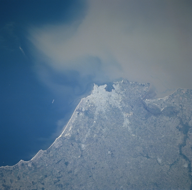 |
| NM23-719-453 Montevideo, Uruguay Winter/Spring 1997 The capital city of Uruguay, Montevideo can be seen in this south-southwest-looking view. Montevideo is on the north shore of the Rio de la Plata and has well-protected harbor and facilities. Much of the South Atlantic fishing fleet is based in Montevideo. The city is the hub of the Uruguayan rail and highway systems that connect with the Argentine and Brazilian networks, as well as for air and sea routes. Montevideo is the commercial, industrial, financial, medical, and cultural center of the country. Over half of the population of Montevideo lives in the metropolitan area. Major industries include slaughtering and meatpacking, flour milling, clothing and textile manufacturing, oil refining, petrochemical and cement production, and power generation. Montevideo is famous for beaches and seaside resorts that stretch eastward from the city to Punta del Este on the Atlantic Ocean. Sediment-laden waters of the Rio de la Plata are visible at upper right and center. A dramatic event in the city's modern history occurred in December 1939 during World War II when the German battleship Graf Spee, already heavily damaged by British warships, was scuttled outside the Montevideo harbor. |
| Images: | All Available Images Low-Resolution 276k |
|
| Mission: | NM23 |
|
| Roll - Frame: | 719 - 453 |
|
| Geographical Name: | URUGUAY |
|
| Features: | MONTEVIDEO |
|
| Center Lat x Lon: | 35S x 56W |
|
| Film Exposure: | N | N=Normal exposure, U=Under exposed, O=Over exposed, F=out of Focus |
| Percentage of Cloud Cover-CLDP: | 0 |
|
| Camera:: | HB |
|
| Camera Tilt: | LO | LO=Low Oblique, HO=High Oblique, NV=Near Vertical |
| Camera Focal Length: | 100 |
|
| Nadir to Photo Center Direction: | SE | The direction from the nadir to the center point, N=North, S=South, E=East, W=West |
| Stereo?: | Y | Y=Yes there is an adjacent picture of the same area, N=No there isn't |
| Orbit Number: | |
|
| Date: | 19970328 | YYYYMMDD |
| Time: | GMT HHMMSS |
|
| Nadir Lat: | N |
Latitude of suborbital point of spacecraft |
| Nadir Lon: | E |
Longitude of suborbital point of spacecraft |
| Sun Azimuth: | Clockwise angle in degrees from north to the sun measured at the nadir point |
|
| Space Craft Altitude: | nautical miles |
|
| Sun Elevation: | Angle in degrees between the horizon and the sun, measured at the nadir point |
|
| Land Views: | PLAIN, COAST |
|
| Water Views: | SEDIMENT, RIVER |
|
| Atmosphere Views: | |
|
| Man Made Views: | URBAN AREA, AGRICULTURE |
|
| City Views: | MONTEVIDEO |
|
Photo is not associated with any sequences | ||
| NASA Home Page |
JSC Home Page |
JSC Digital Image Collection |
Earth Science & Remote Sensing |
|
This service is provided by the International Space Station program and the JSC Earth Science & Remote Sensing Unit, ARES Division, Exploration Integration Science Directorate.

|