Geographic Region: PARAGUAY
Feature: RIO YGUAZU RESERVOIR
|
Geographic Region: PARAGUAY Feature: RIO YGUAZU RESERVOIR |
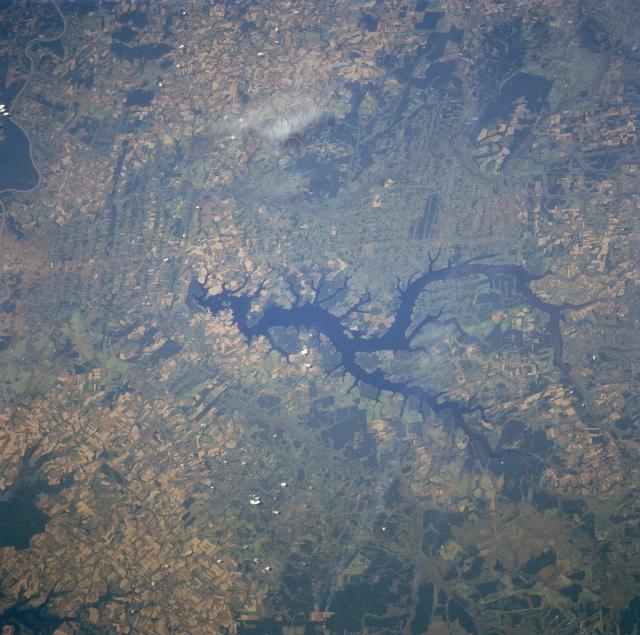 |
| NM23-716-395 Yguazu River Reservoir, Paraguay Winter/Spring 1997 The light colors of the overall picture indicates that most of the landscape in this region of southeast Paraguay has been cleared of trees in favor of intensive agricultural activities. Most of the croplands are used to grow cotton and soybeans, while pasture grasses are used to raise cattle. This region of Paraguay, known as the Paranena, is a mixture of rolling hills, plateaus, and broad valleys. The dark, irregular shaped feature in the middle of the image is a reservoir created by building a dam on the Rio Yguazu (dam is on eastern end of the reservoir). Several small, forested areas are visible north and south of the Reservoir (uniform dark green patches). These forests occur mainly along the river valleys and wetlands of the Rio Monday (south) and Rio Acaray (north of the reservoir). |
| Images: | All Available Images Low-Resolution 363k |
|
| Mission: | NM23 |
|
| Roll - Frame: | 716 - 395 |
|
| Geographical Name: | PARAGUAY |
|
| Features: | RIO YGUAZU RESERVOIR |
|
| Center Lat x Lon: | 25.5S x 55W |
|
| Film Exposure: | N | N=Normal exposure, U=Under exposed, O=Over exposed, F=out of Focus |
| Percentage of Cloud Cover-CLDP: | 0 |
|
| Camera:: | HB |
|
| Camera Tilt: | LO | LO=Low Oblique, HO=High Oblique, NV=Near Vertical |
| Camera Focal Length: | 250 |
|
| Nadir to Photo Center Direction: | E | The direction from the nadir to the center point, N=North, S=South, E=East, W=West |
| Stereo?: | Y | Y=Yes there is an adjacent picture of the same area, N=No there isn't |
| Orbit Number: | |
|
| Date: | 19970321 | YYYYMMDD |
| Time: | GMT HHMMSS |
|
| Nadir Lat: | N |
Latitude of suborbital point of spacecraft |
| Nadir Lon: | E |
Longitude of suborbital point of spacecraft |
| Sun Azimuth: | Clockwise angle in degrees from north to the sun measured at the nadir point |
|
| Space Craft Altitude: | nautical miles |
|
| Sun Elevation: | Angle in degrees between the horizon and the sun, measured at the nadir point |
|
| Land Views: | HILL, FOREST |
|
| Water Views: | RESERVOIR, RIVER |
|
| Atmosphere Views: | |
|
| Man Made Views: | AGRICULTURE |
|
| City Views: | |
|
Photo is not associated with any sequences | ||
| NASA Home Page |
JSC Home Page |
JSC Digital Image Collection |
Earth Science & Remote Sensing |
|
This service is provided by the International Space Station program and the JSC Earth Science & Remote Sensing Unit, ARES Division, Exploration Integration Science Directorate.

|