Geographic Region: ALBANIA
Feature: LAKE OHRID
|
Geographic Region: ALBANIA Feature: LAKE OHRID |
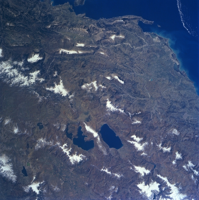 |
| NM23-707-426 Lakes Ohrid & Prespa, Albania/Macedonia Winter/Spring 1997 Located just below the center of the image, Lake Ohrid, the deepest lake in the Balkans, can be seen in this south-southeast looking view. Just to the left of Lake Ohrid is Lake Prespa, the highest lake in the Balkans. The smaller Mikri Prespa is just to the left (east) of Lake Prespa. Lake Ohrid is 25 miles (40 km) long and covers and area of 130 sq. miles (340 sq. km). Lake Prespa is 14 miles (23 km) long and approximately 8 miles (13 km) wide and covers an area of 112 sq. miles (290 sq. km). Lake Prespa drains into Lake Ohrid through a series of underground channels. The terrain around the lakes is hilly but not overly steep. The region around the lakes supports a larger population than other inland areas in Albania, northern Greece, and Macedonia. Most of Albania is visible in this view (right of the lakes). The terrain, except for a narrow coastal plain, is mountainous and often inaccessible. Soils are of a poor quality except in the intermontaine river valleys, along Lakes Orhid and Prespa. The Vlores Gulf and Adriatic Sea are visible in the top right corner of the image. |
| Images: | All Available Images Low-Resolution 360k |
|
| Mission: | NM23 |
|
| Roll - Frame: | 707 - 426 |
|
| Geographical Name: | ALBANIA |
|
| Features: | LAKE OHRID |
|
| Center Lat x Lon: | 40.5N x 20.5E |
|
| Film Exposure: | N | N=Normal exposure, U=Under exposed, O=Over exposed, F=out of Focus |
| Percentage of Cloud Cover-CLDP: | 5 |
|
| Camera:: | HB |
|
| Camera Tilt: | LO | LO=Low Oblique, HO=High Oblique, NV=Near Vertical |
| Camera Focal Length: | 100 |
|
| Nadir to Photo Center Direction: | E | The direction from the nadir to the center point, N=North, S=South, E=East, W=West |
| Stereo?: | Y | Y=Yes there is an adjacent picture of the same area, N=No there isn't |
| Orbit Number: | |
|
| Date: | 19970312 | YYYYMMDD |
| Time: | GMT HHMMSS |
|
| Nadir Lat: | N |
Latitude of suborbital point of spacecraft |
| Nadir Lon: | E |
Longitude of suborbital point of spacecraft |
| Sun Azimuth: | Clockwise angle in degrees from north to the sun measured at the nadir point |
|
| Space Craft Altitude: | nautical miles |
|
| Sun Elevation: | Angle in degrees between the horizon and the sun, measured at the nadir point |
|
| Land Views: | COAST, MOUNTAIN, PLATEAU, FAULT |
|
| Water Views: | LAKE |
|
| Atmosphere Views: | |
|
| Man Made Views: | |
|
| City Views: | |
|
Photo is not associated with any sequences | ||
| NASA Home Page |
JSC Home Page |
JSC Digital Image Collection |
Earth Science & Remote Sensing |
|
This service is provided by the International Space Station program and the JSC Earth Science & Remote Sensing Unit, ARES Division, Exploration Integration Science Directorate.

|