
Geographic Region: USA-WASHINGTON
Feature: SPOKANE, SPOKANE R.,AGR.
|
Geographic Region: USA-WASHINGTON Feature: SPOKANE, SPOKANE R.,AGR. |
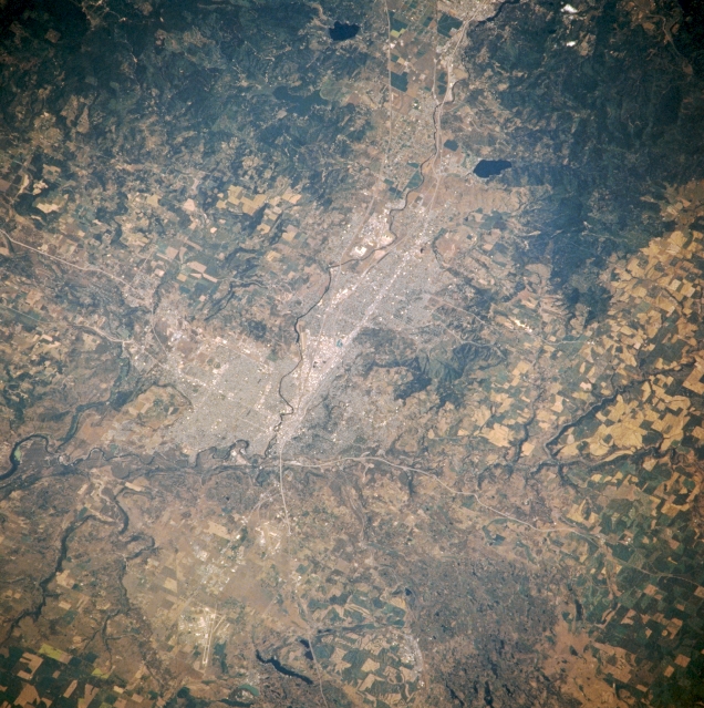 |
| NM21-768-018 Spokane, Washington, U.S.A. Winter 1995-1996 Spokane appears at the center of this east-northeast-looking, low-oblique photograph. Interstate Highway 90 extends from the Idaho-Washington border (right of top center) through Spokane, some 18 miles (29 kilometers) distant, before veering southwest. The runways of Fairchild Air Force Base are discernible near the bottom of the photograph just north of Interstate Highway 90. Spokane is a commercial, transportation, agricultural, and industrial center in the midst of an extensive recreational region that has many lakes and a number of national and state parks. |
| Images: | All Available Images Low-Resolution 389k |
|
| Mission: | NM21 |
|
| Roll - Frame: | 768 - 18 |
|
| Geographical Name: | USA-WASHINGTON |
|
| Features: | SPOKANE, SPOKANE R.,AGR. |
|
| Center Lat x Lon: | 47.5N x 117.5W |
|
| Film Exposure: | N | N=Normal exposure, U=Under exposed, O=Over exposed, F=out of Focus |
| Percentage of Cloud Cover-CLDP: | 0 |
|
| Camera:: | HB |
|
| Camera Tilt: | 48 | LO=Low Oblique, HO=High Oblique, NV=Near Vertical |
| Camera Focal Length: | 250 |
|
| Nadir to Photo Center Direction: | W | The direction from the nadir to the center point, N=North, S=South, E=East, W=West |
| Stereo?: | N | Y=Yes there is an adjacent picture of the same area, N=No there isn't |
| Orbit Number: | 55 |
|
| Date: | 19960706 | YYYYMMDD |
| Time: | 175350 | GMT HHMMSS |
| Nadir Lat: | 46.1N |
Latitude of suborbital point of spacecraft |
| Nadir Lon: | 114W |
Longitude of suborbital point of spacecraft |
| Sun Azimuth: | 128 | Clockwise angle in degrees from north to the sun measured at the nadir point |
| Space Craft Altitude: | 207 | nautical miles |
| Sun Elevation: | 58 | Angle in degrees between the horizon and the sun, measured at the nadir point |
| Land Views: | |
|
| Water Views: | |
|
| Atmosphere Views: | |
|
| Man Made Views: | URBAN AREA, AGRICULTURE |
|
| City Views: | SPOKANE |
|
Photo is not associated with any sequences | ||
| NASA Home Page |
JSC Home Page |
JSC Digital Image Collection |
Earth Science & Remote Sensing |
|
This service is provided by the International Space Station program and the JSC Earth Science & Remote Sensing Unit, ARES Division, Exploration Integration Science Directorate.

|