
Geographic Region: USA-WISCONSIN
Feature: MILWAUKEE, LAKE MICHIGAN
|
Geographic Region: USA-WISCONSIN Feature: MILWAUKEE, LAKE MICHIGAN |
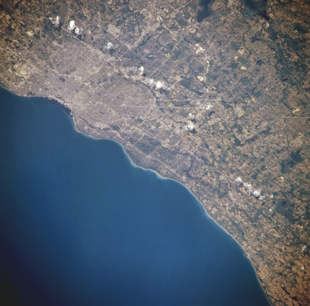 |
| NM21-765-047 Milwaukee, Wisconsin, U.S.A. Winter 1995-1996 Milwaukee, the largest city in Wisconsin, is visible in this southwest-looking, low-oblique photograph. Located where the Milwaukee, Menomonee, and Kinnickinnic Rivers enter Lake Michigan, Milwaukee is a port of entry for heavy cargo via the Saint Lawrence Seaway. The city, a major center of German immigration in the last half of the 1800s, is one of the world's leading manufacturers of diesel and gasoline engines, tractors, and beer. The runways of Billy Mitchell International Airport are discernible south of the city (upper left). Numerous parks and recreational areas dot much of the shoreline north of the city. |
| Images: | All Available Images Low-Resolution 339k |
|
| Mission: | NM21 |
|
| Roll - Frame: | 765 - 47 |
|
| Geographical Name: | USA-WISCONSIN |
|
| Features: | MILWAUKEE, LAKE MICHIGAN |
|
| Center Lat x Lon: | 43.0N x 88W |
|
| Film Exposure: | N | N=Normal exposure, U=Under exposed, O=Over exposed, F=out of Focus |
| Percentage of Cloud Cover-CLDP: | 5 |
|
| Camera:: | HB |
|
| Camera Tilt: | 21 | LO=Low Oblique, HO=High Oblique, NV=Near Vertical |
| Camera Focal Length: | 250 |
|
| Nadir to Photo Center Direction: | W | The direction from the nadir to the center point, N=North, S=South, E=East, W=West |
| Stereo?: | Y | Y=Yes there is an adjacent picture of the same area, N=No there isn't |
| Orbit Number: | 999 |
|
| Date: | 19960703 | YYYYMMDD |
| Time: | 165250 | GMT HHMMSS |
| Nadir Lat: | 42.7N |
Latitude of suborbital point of spacecraft |
| Nadir Lon: | 86.7W |
Longitude of suborbital point of spacecraft |
| Sun Azimuth: | 143 | Clockwise angle in degrees from north to the sun measured at the nadir point |
| Space Craft Altitude: | 208 | nautical miles |
| Sun Elevation: | 67 | Angle in degrees between the horizon and the sun, measured at the nadir point |
| Land Views: | |
|
| Water Views: | LAKE |
|
| Atmosphere Views: | |
|
| Man Made Views: | URBAN AREA |
|
| City Views: | MILWAUKEE |
|
Photo is not associated with any sequences | ||
| NASA Home Page |
JSC Home Page |
JSC Digital Image Collection |
Earth Science & Remote Sensing |
|
This service is provided by the International Space Station program and the JSC Earth Science & Remote Sensing Unit, ARES Division, Exploration Integration Science Directorate.

|