
Geographic Region: USA-ILLINOIS
Feature: CHICAGO, LAKE MICHIGAN
|
Geographic Region: USA-ILLINOIS Feature: CHICAGO, LAKE MICHIGAN |
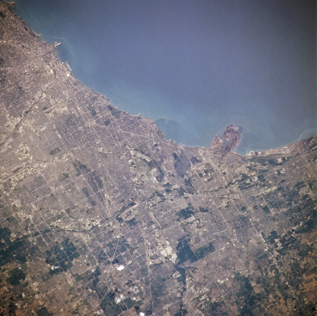 |
| NM21-765-043 Lake Michigan and South Chicago, Illinois, U.S.A. Winter 1995-1996 Featured in this northeast-looking, low-oblique photograph are the southern end of Lake Michigan and a small portion of central Chicago from near downtown (the loop) through southern Chicago to the northwestern Indiana cities of Hammond, East Chicago, and Gary (near right center). Most of Chicago's heavy industry--steel fabrication plants, iron and steel mills, and chemical plants--are located in this area. Just south of Interstate Highway 55 is Chicago Midway Airport (barely discernible near left center). Visible is Chicago Merrill C. Meigs Field, a small airport protruding into Lake Michigan and paralleling the shoreline. (Refer to NM21-765-044 for a photograph of central and north Chicago.) |
| Images: | All Available Images Low-Resolution 353k |
|
| Mission: | NM21 |
|
| Roll - Frame: | 765 - 43 |
|
| Geographical Name: | USA-ILLINOIS |
|
| Features: | CHICAGO, LAKE MICHIGAN |
|
| Center Lat x Lon: | 41.5N x 87.5W |
|
| Film Exposure: | N | N=Normal exposure, U=Under exposed, O=Over exposed, F=out of Focus |
| Percentage of Cloud Cover-CLDP: | 0 |
|
| Camera:: | HB |
|
| Camera Tilt: | 21 | LO=Low Oblique, HO=High Oblique, NV=Near Vertical |
| Camera Focal Length: | 250 |
|
| Nadir to Photo Center Direction: | E | The direction from the nadir to the center point, N=North, S=South, E=East, W=West |
| Stereo?: | Y | Y=Yes there is an adjacent picture of the same area, N=No there isn't |
| Orbit Number: | 999 |
|
| Date: | 19960703 | YYYYMMDD |
| Time: | 165219 | GMT HHMMSS |
| Nadir Lat: | 41.6N |
Latitude of suborbital point of spacecraft |
| Nadir Lon: | 88.8W |
Longitude of suborbital point of spacecraft |
| Sun Azimuth: | 137 | Clockwise angle in degrees from north to the sun measured at the nadir point |
| Space Craft Altitude: | 208 | nautical miles |
| Sun Elevation: | 67 | Angle in degrees between the horizon and the sun, measured at the nadir point |
| Land Views: | |
|
| Water Views: | LAKE |
|
| Atmosphere Views: | |
|
| Man Made Views: | URBAN AREA, AIRPORT |
|
| City Views: | CHICAGO |
|
Photo is not associated with any sequences | ||
| NASA Home Page |
JSC Home Page |
JSC Digital Image Collection |
Earth Science & Remote Sensing |
|
This service is provided by the International Space Station program and the JSC Earth Science & Remote Sensing Unit, ARES Division, Exploration Integration Science Directorate.

|