
Geographic Region: CANADA-O
Feature: LAKE OF THE WOODS, AGR.
|
Geographic Region: CANADA-O Feature: LAKE OF THE WOODS, AGR. |
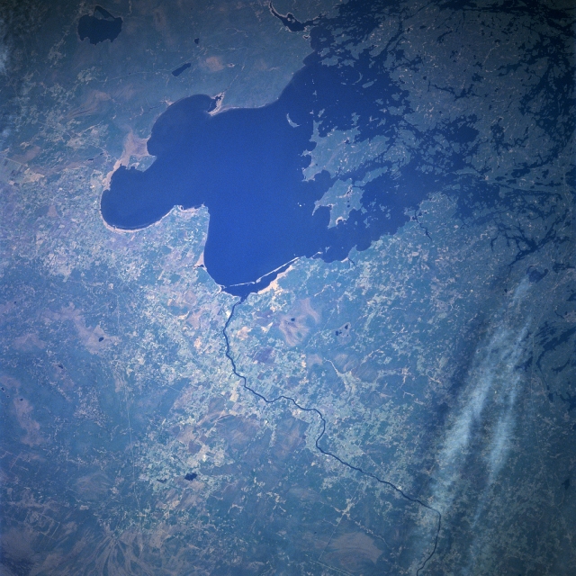 |
| NASA7-723-036 Lake of the Woods, Ontario, Canada May, 1998 The second largest inland lake in Ontario, Lake of the Woods can be seen in this west-northwest looking low-oblique view. Lake of the Woods is nearly 100 miles (161 km) long, 70 miles (115 km) wide, and covers an area of 1485 square miles (3846 sq km). Located in the southern Canadian Shield, Lake of the Woods was once part of the ancient glacial Lake Agassiz. The lake, with more than 14000 islands and almost 65000 miles (104650 km) of shoreline, is a resort area renowned for excellent fishing and other recreational activities. Headwaters of the Rainy River (right of center) are around Rainy Lake near International Falls, Minnesota (not visible on the image). The Rainy River flows 85 miles (135 km) westward along the Canadian and United States border before entering the Lake of the Woods. |
| Images: | All Available Images Low-Resolution 357k |
|
| Mission: | NASA7 |
|
| Roll - Frame: | 723 - 36 |
|
| Geographical Name: | CANADA-O |
|
| Features: | LAKE OF THE WOODS, AGR. |
|
| Center Lat x Lon: | 49.0N x 94.5W |
|
| Film Exposure: | N | N=Normal exposure, U=Under exposed, O=Over exposed, F=out of Focus |
| Percentage of Cloud Cover-CLDP: | 5 |
|
| Camera:: | HB |
|
| Camera Tilt: | LO | LO=Low Oblique, HO=High Oblique, NV=Near Vertical |
| Camera Focal Length: | 100 |
|
| Nadir to Photo Center Direction: | The direction from the nadir to the center point, N=North, S=South, E=East, W=West |
|
| Stereo?: | Y | Y=Yes there is an adjacent picture of the same area, N=No there isn't |
| Orbit Number: | |
|
| Date: | 19980510 | YYYYMMDD |
| Time: | GMT HHMMSS |
|
| Nadir Lat: | N |
Latitude of suborbital point of spacecraft |
| Nadir Lon: | E |
Longitude of suborbital point of spacecraft |
| Sun Azimuth: | Clockwise angle in degrees from north to the sun measured at the nadir point |
|
| Space Craft Altitude: | nautical miles |
|
| Sun Elevation: | Angle in degrees between the horizon and the sun, measured at the nadir point |
|
| Land Views: | FOREST, PLAIN |
|
| Water Views: | LAKE, RIVER |
|
| Atmosphere Views: | |
|
| Man Made Views: | |
|
| City Views: | |
|
Photo is not associated with any sequences | ||
| NASA Home Page |
JSC Home Page |
JSC Digital Image Collection |
Earth Science & Remote Sensing |
|
This service is provided by the International Space Station program and the JSC Earth Science & Remote Sensing Unit, ARES Division, Exploration Integration Science Directorate.

|