Geographic Region: ITALY
Feature: GULF OF TRIESTE, TRIESTE
|
Geographic Region: ITALY Feature: GULF OF TRIESTE, TRIESTE |
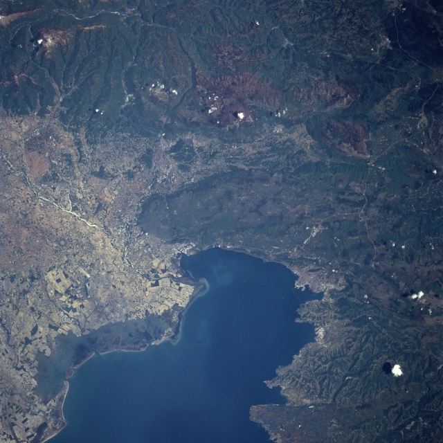 |
| NASA7-722-46H Gulf of Trieste, Italy Spring 1998 The dark-looking waters of the Gulf of Trieste (bottom center) is located at the northern end of the Adriatic Sea. The gulf is bounded by Italy on the north and east and by Slovenia on the southeast. Three small Slovenian port cities (Piran, Izola, and Koper) are located along the coastline. A narrow strip of land that encircles most of the gulf belongs to Italy. The only exception is the above mentioned northwest coast of the Istrian Peninsula (only part of the peninsula is visible in this picture)in the lower right corner of the scene. The historic and picturesque seaside city of Trieste is barely discernible along the eastern edge of the Gulf of Trieste. The darker colored landscape throughout most of the image is rugged, forested mountains. An area of coastal wetlands in northeast Italy (lower left) also has a dark appearance (along the northwest coast of the Gulf of Trieste). The lighter colored mottled-looking landscape (left center) is part of the coastal plains where a variety of crops are produced. The light-colored, linear feature (middle left) is part of the Isonzo River that drains eastern Italy. A small delta is visible where the Isonzo River drains into the north side of the Gulf of Trieste. |
| Images: | All Available Images Low-Resolution 345k |
|
| Mission: | NASA7 |
|
| Roll - Frame: | 722 - 46 H |
|
| Geographical Name: | ITALY |
|
| Features: | GULF OF TRIESTE, TRIESTE |
|
| Center Lat x Lon: | 46.0N x 14.0E |
|
| Film Exposure: | N | N=Normal exposure, U=Under exposed, O=Over exposed, F=out of Focus |
| Percentage of Cloud Cover-CLDP: | 0 |
|
| Camera:: | HB |
|
| Camera Tilt: | LO | LO=Low Oblique, HO=High Oblique, NV=Near Vertical |
| Camera Focal Length: | 250 |
|
| Nadir to Photo Center Direction: | The direction from the nadir to the center point, N=North, S=South, E=East, W=West |
|
| Stereo?: | Y | Y=Yes there is an adjacent picture of the same area, N=No there isn't |
| Orbit Number: | |
|
| Date: | 19980508 | YYYYMMDD |
| Time: | GMT HHMMSS |
|
| Nadir Lat: | N |
Latitude of suborbital point of spacecraft |
| Nadir Lon: | E |
Longitude of suborbital point of spacecraft |
| Sun Azimuth: | Clockwise angle in degrees from north to the sun measured at the nadir point |
|
| Space Craft Altitude: | nautical miles |
|
| Sun Elevation: | Angle in degrees between the horizon and the sun, measured at the nadir point |
|
| Land Views: | MOUNTAIN, PLAIN |
|
| Water Views: | GULF, SWAMP |
|
| Atmosphere Views: | |
|
| Man Made Views: | |
|
| City Views: | |
|
Photo is not associated with any sequences | ||
| NASA Home Page |
JSC Home Page |
JSC Digital Image Collection |
Earth Science & Remote Sensing |
|
This service is provided by the International Space Station program and the JSC Earth Science & Remote Sensing Unit, ARES Division, Exploration Integration Science Directorate.

|