
Geographic Region: USA-UTAH
Feature: L. UTAH, WASATCH RA., PROVO
|
Geographic Region: USA-UTAH Feature: L. UTAH, WASATCH RA., PROVO |
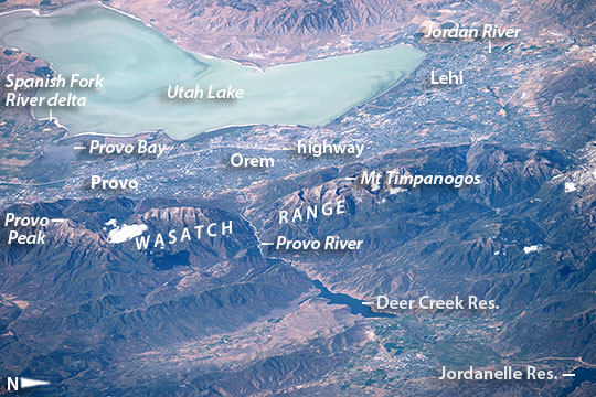 |
| Lake Utah and Provo From a point near the Black Hills an astronaut aboard the International Space Station looked more than 700 km (400 miles) west and focused on the shorelines of lakes in Utah. Shorelines are easy to see from space and often indicate interesting centers of human activity. Being so far away the astronaut used a powerful 800 mm lens for this panoramic shot of Lake Utah, just south of Great Salt Lake. Utah Lake's only river outlet is the Jordan River (at image top right), which leads water to the Great Salt Lake at times when the lake is high. The lower part of the image shows the thickly wooded Wasatch Range that rises so high above the city that it captures rain. Provo Peak and Mt Timpanogos are two well-known local peaks. Utah Lake is so shallow that surface waves stir up light-toned muds from the lake bottom, giving the lake a light green-blue hue (at image top). Across the middle of the image gray tones show the Provo-Orem metropolitan area that fringes the length of the lake. The lake is 33 km (20 miles) long, giving a sense of the extent of the metro area. The Veterans Memorial Highway is a straight white line running through the entire metro area in the view, from Provo to Lehi. All the green tones are farms that fringe the cities, right down to the water's edge. Finding water for a population of more than half a million (526,800), and for local farming has always been problematic in arid Utah. Luckily snow and rainfall on the wetter Wasatch Range nearby provide enough water for these populations--with careful reuse of water. The main water supply points are the lake itself and rivers like the Provo and Spanish Fork that help fill the lake. These long rivers cut through the main Wasatch Range in dramatic canyons. The Provo River canyon appears at image center, and the delta of the Spanish Fork River juts into the lake (at image far left) south of Provo Bay. Dark shapes on the Provo River are the Deer Creek and Jordanelle reservoirs at image lower right. |
| Images: | All Available Images Low-Resolution 125k |
|
| Mission: | ISS048 |
|
| Roll - Frame: | E - 73267 |
|
| Geographical Name: | USA-UTAH |
|
| Features: | L. UTAH, WASATCH RA., PROVO |
|
| Center Lat x Lon: | 40.4N x 111.6W |
|
| Film Exposure: | N=Normal exposure, U=Under exposed, O=Over exposed, F=out of Focus |
|
| Percentage of Cloud Cover-CLDP: | 10 |
|
| Camera:: | N6 |
|
| Camera Tilt: | HO | LO=Low Oblique, HO=High Oblique, NV=Near Vertical |
| Camera Focal Length: | 800 |
|
| Nadir to Photo Center Direction: | W | The direction from the nadir to the center point, N=North, S=South, E=East, W=West |
| Stereo?: | Y=Yes there is an adjacent picture of the same area, N=No there isn't |
|
| Orbit Number: | |
|
| Date: | 20160906 | YYYYMMDD |
| Time: | 172738 | GMT HHMMSS |
| Nadir Lat: | 42.8N |
Latitude of suborbital point of spacecraft |
| Nadir Lon: | 103.6W |
Longitude of suborbital point of spacecraft |
| Sun Azimuth: | 147 | Clockwise angle in degrees from north to the sun measured at the nadir point |
| Space Craft Altitude: | 216 | nautical miles |
| Sun Elevation: | 49 | Angle in degrees between the horizon and the sun, measured at the nadir point |
| Land Views: | RANGE |
|
| Water Views: | BAY, DELTA, LAKE, RIVER |
|
| Atmosphere Views: | |
|
| Man Made Views: | HIGHWAY |
|
| City Views: | |
|
Photo is not associated with any sequences | ||
| NASA Home Page |
JSC Home Page |
JSC Digital Image Collection |
Earth Science & Remote Sensing |
|
This service is provided by the International Space Station program and the JSC Earth Science & Remote Sensing Unit, ARES Division, Exploration Integration Science Directorate.

|