Geographic Region: USA-TEXAS
Feature: SAN ANTONIO, HIGHWAYS
|
Geographic Region: USA-TEXAS Feature: SAN ANTONIO, HIGHWAYS |
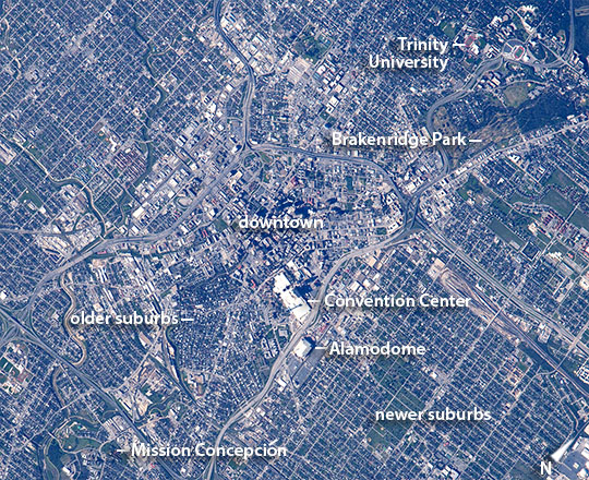 |
| San Antonio, Texas A crew member aboard the International Space Station took several detailed images of San Antonio in central Texas. Founded in 1691, San Antonio has been central to the history of northern Mexico and the southwestern USA. Several streams (image left) served as the original center of population in the region. High rise buildings in the city center cast long shadows. The Convention Center complex and the Alamo Dome sports complex dominate the view of the city center from space. This detailed image even shows the shadow of the 750-foot tall (355 meters) Tower of the Americas falling across the convention center roof. Immediately south and east of downtown the small nineteenth-century residential zone of the city appears as a dense non-orthogonal street pattern -- quite unlike the newer suburbs which show a more rectangular pattern and cover much wider areas. The city now ranks as the seventh most populated in the USA with a population of 1,409,000, and boasted the fastest growth in the country between 2000 and 2010. Major interstate highways cross the image as gently curving features that compete with the stream courses as visual features. Campuses of two universities, Trinity and Incarnate Word, extend the green space of the large Brackenridge Park (image upper right). Inhabitants are justly proud of the historical heritage of the city which includes six preserved colonial mission churches. The mission nearest the city center, Mission Concepcion, lies south of the city (image lower left). The convention facilities and the historical character of the city bring 26 million visitors to the city every year. |
| Images: | All Available Images Low-Resolution 231k |
|
| Mission: | ISS046 |
|
| Roll - Frame: | E - 5093 |
|
| Geographical Name: | USA-TEXAS |
|
| Features: | SAN ANTONIO, HIGHWAYS |
|
| Center Lat x Lon: | 29.4N x 98.5W |
|
| Film Exposure: | N=Normal exposure, U=Under exposed, O=Over exposed, F=out of Focus |
|
| Percentage of Cloud Cover-CLDP: | 0 |
|
| Camera:: | N6 |
|
| Camera Tilt: | 24 | LO=Low Oblique, HO=High Oblique, NV=Near Vertical |
| Camera Focal Length: | 1150 |
|
| Nadir to Photo Center Direction: | S | The direction from the nadir to the center point, N=North, S=South, E=East, W=West |
| Stereo?: | Y=Yes there is an adjacent picture of the same area, N=No there isn't |
|
| Orbit Number: | |
|
| Date: | 20160104 | YYYYMMDD |
| Time: | 201413 | GMT HHMMSS |
| Nadir Lat: | 30.9N |
Latitude of suborbital point of spacecraft |
| Nadir Lon: | 97.9W |
Longitude of suborbital point of spacecraft |
| Sun Azimuth: | 207 | Clockwise angle in degrees from north to the sun measured at the nadir point |
| Space Craft Altitude: | 217 | nautical miles |
| Sun Elevation: | 32 | Angle in degrees between the horizon and the sun, measured at the nadir point |
| Land Views: | |
|
| Water Views: | |
|
| Atmosphere Views: | |
|
| Man Made Views: | |
|
| City Views: | |
|
Photo is not associated with any sequences | ||
| NASA Home Page |
JSC Home Page |
JSC Digital Image Collection |
Earth Science & Remote Sensing |
|
This service is provided by the International Space Station program and the JSC Earth Science & Remote Sensing Unit, ARES Division, Exploration Integration Science Directorate.

|