Geographic Region: EGYPT
Feature: BAWITI OASIS
|
Geographic Region: EGYPT Feature: BAWITI OASIS |
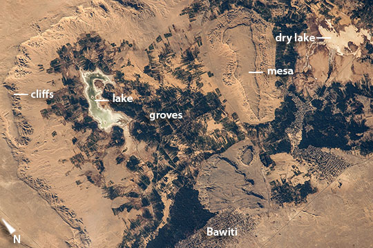 |
| Bahariya Oasis, Western Desert, Egypt Scanning the monotonous tan-colored surface of the Sahara Desert, an astronaut aboard the International Space Station saw small dark patches next to a long, ragged cliff in Egypt's Western Desert. The dark patches are date and olive groves in the Bahariya Oasis (population 27,000), one of several small places in Egypt's deserts beyond the Nile Valley where people can live. The steep cliffs surround a depression in the desert surface, at the bottom of which lies a small lake (at image upper left). The depression is punctuated by a flat-topped hill (mesa) surrounded by lower cliffs. The town of Bawiti where most people live (at image lower center margin) is harder to detect. Bahariya is one of several large depressions west of the River Nile in what is known as the Western Desert that are deep enough to reach underground water. The oasis has a rich history, going back at least to Egypt's Middle Kingdom (2000-1800 BCE, from which time agricultural products have been exported to the Nile Valley. Alexander the Great may have passed through this oasis even though it is so remote (380 km southwest of Cairo). The Valley of the Golden Mummies in Bahariya may hold up to 10,000 undisturbed mummies of Roman and Greek aristocrats, dating from 332 B.C. to 395 A.D. Roman aqueducts are still used to lead water to the fields. Now, modern life has arrived with a good road established between the oasis and Cairo resulting in significant tourist traffic as people come to see remnants of the ancient life of a desert oasis. A nearby iron mine supports many people from Bahariya. In this wider astronaut view [ISS016-E-10073], the groves of the oasis appear as small dark patches at image center, against the wider, vegetationless desert surfaces. In a panoramic view of the Nile delta and Mediterranean Sea [ISS028-E-12612], the specks of the Bahariya date and olive groves (at image lower left corner) almost disappear in the Western Desert, far to the southwest of the delta. |
| Images: | All Available Images Low-Resolution 132k |
|
| Mission: | ISS045 |
|
| Roll - Frame: | E - 55907 |
|
| Geographical Name: | EGYPT |
|
| Features: | BAWITI OASIS |
|
| Center Lat x Lon: | 28.4N x 28.9E |
|
| Film Exposure: | N=Normal exposure, U=Under exposed, O=Over exposed, F=out of Focus |
|
| Percentage of Cloud Cover-CLDP: | 10 |
|
| Camera:: | N6 |
|
| Camera Tilt: | 24 | LO=Low Oblique, HO=High Oblique, NV=Near Vertical |
| Camera Focal Length: | 1150 |
|
| Nadir to Photo Center Direction: | W | The direction from the nadir to the center point, N=North, S=South, E=East, W=West |
| Stereo?: | Y=Yes there is an adjacent picture of the same area, N=No there isn't |
|
| Orbit Number: | |
|
| Date: | 20151010 | YYYYMMDD |
| Time: | 133811 | GMT HHMMSS |
| Nadir Lat: | 28.8N |
Latitude of suborbital point of spacecraft |
| Nadir Lon: | 30.4E |
Longitude of suborbital point of spacecraft |
| Sun Azimuth: | 247 | Clockwise angle in degrees from north to the sun measured at the nadir point |
| Space Craft Altitude: | 214 | nautical miles |
| Sun Elevation: | 24 | Angle in degrees between the horizon and the sun, measured at the nadir point |
| Land Views: | DESERT, HILL |
|
| Water Views: | LAKE, RIVER |
|
| Atmosphere Views: | |
|
| Man Made Views: | |
|
| City Views: | |
|
Photo is not associated with any sequences | ||
| NASA Home Page |
JSC Home Page |
JSC Digital Image Collection |
Earth Science & Remote Sensing |
|
This service is provided by the International Space Station program and the JSC Earth Science & Remote Sensing Unit, ARES Division, Exploration Integration Science Directorate.

|