Geographic Region: ARGENTINA
Feature: ANDES MTS., HAZE, MENDOZA R., SANTIAGO
|
Geographic Region: ARGENTINA Feature: ANDES MTS., HAZE, MENDOZA R., SANTIAGO |
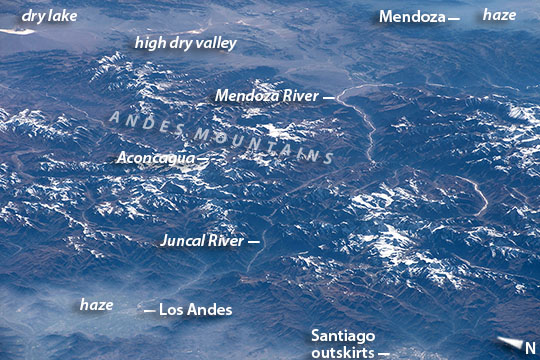 |
| Pan-American Highway, Southern Andes Mountains, Chile and Argentina From 700 km distance over the Pacific Ocean, an astronaut aboard the International Space Station took this oblique image of a part of the Andes Mountains. The mountain ranges cross the entire image and form the border between in Chile in the foreground and Argentina's wine country (across the top of the image). This view is unusual because it reveals precisely the canyons and valleys followed by the Pan America Highway: the spacecraft and sun were in just the right positions for the sun's reflection to reveal the thin bright rivers in the deep valleys followed by the highway. The pass over the Andes is the main route between Chile's capital Santiago, whose outskirts appear at image lower right, and Mendoza, the heart of Argentina's winemaking industry. Mendoza's basin lies under haze at image top right corner. The highway route over the Andes starts just north of Chile's capital city Santiago at the small town of Los Andes (at image lower left), snaking its way up the forested Juncal River valley where it passes close to Aconcagua, the highest mountain peak in the Western Hemisphere (6959 m, 22,830 feet)(at image left center). Near Aconcagua the highway crosses the international boundary into the Mendoza River valley where it passes through a high, treeless desert valley (with a dry lake at image top left corner). Then the highway bends southeast and descends to the Mendoza basin, marked here by a blanket of haze. Haze, a variable mix of smoke, dust and fog, is a typical winter phenomenon on windless days, as seen also in the basins in Chile where Santiago and Los Andes are located. The Pan-American Highway is an almost continuous road, 30,000 kilometers (19,000 mi) long, that joins seventeen countries in the Americas, from southernmost South America up through North America to the Arctic Ocean. Despite frequent haze, the Santiago region of Chile is a favorite target for photographers in space (ISS040-E-10803, ISS022-E-75457). |
| Images: | All Available Images Low-Resolution 125k |
|
| Mission: | ISS043 |
|
| Roll - Frame: | E - 83229 |
|
| Geographical Name: | ARGENTINA |
|
| Features: | ANDES MTS., HAZE, MENDOZA R., SANTIAGO |
|
| Center Lat x Lon: | 32.8S x 70W |
|
| Film Exposure: | N=Normal exposure, U=Under exposed, O=Over exposed, F=out of Focus |
|
| Percentage of Cloud Cover-CLDP: | 10 |
|
| Camera:: | N6 |
|
| Camera Tilt: | HO | LO=Low Oblique, HO=High Oblique, NV=Near Vertical |
| Camera Focal Length: | 290 |
|
| Nadir to Photo Center Direction: | NE | The direction from the nadir to the center point, N=North, S=South, E=East, W=West |
| Stereo?: | Y=Yes there is an adjacent picture of the same area, N=No there isn't |
|
| Orbit Number: | |
|
| Date: | 20150402 | YYYYMMDD |
| Time: | 133743 | GMT HHMMSS |
| Nadir Lat: | 36.9S |
Latitude of suborbital point of spacecraft |
| Nadir Lon: | 77W |
Longitude of suborbital point of spacecraft |
| Sun Azimuth: | 62 | Clockwise angle in degrees from north to the sun measured at the nadir point |
| Space Craft Altitude: | 217 | nautical miles |
| Sun Elevation: | 25 | Angle in degrees between the horizon and the sun, measured at the nadir point |
| Land Views: | BASIN, DESERT, MOUNTAIN, VALLEY |
|
| Water Views: | LAKE, OCEAN, RIVER |
|
| Atmosphere Views: | DUST, FOG, HAZE, SMOKE |
|
| Man Made Views: | HIGHWAY |
|
| City Views: | SANTIAGO |
|
Photo is not associated with any sequences | ||
| NASA Home Page |
JSC Home Page |
JSC Digital Image Collection |
Earth Science & Remote Sensing |
|
This service is provided by the International Space Station program and the JSC Earth Science & Remote Sensing Unit, ARES Division, Exploration Integration Science Directorate.

|