Geographic Region: CANADA-NB
Feature: PRINCE EDWARD I., G. SAINT LAWRENCE
|
Geographic Region: CANADA-NB Feature: PRINCE EDWARD I., G. SAINT LAWRENCE |
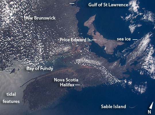 |
| Nova Scotia, Prince Edward Island, Canada Astronauts aboard the International Space Station took this near-vertical image with a "wide-angle" lens--the same focal length as the human eye, showing what crews actually see. The view shows the characteristic coastlines of the Nova Scotia peninsula on Canada's eastern seaboard, separated from the mainland by the Bay of Fundy (image center). The bay experiences the largest tidal fluctuations (~16 m, 50 feet) in the world. The enormous exchange of water twice a day is partly responsible for the red sediment visible in the headwaters of the bay. Timber-cuts make the linear patterns on the eastern part of the boat-shaped province of Prince Edward Island (image center right) in the Gulf of St Lawrence. This is Canada's smallest and only island province. A long tendril of sea ice streams south from Nova Scotia's clouded, northernmost cape (image top right). The bright reflection of the sun (image upper left) shows intersecting tidal features in the sea surface resulting from both the Fundy tides and those tides propagating in from the Atlantic Ocean. Cities are difficult to see from space in daylight hours. Of the many cities that would appear in night views of the area, only Nova Scotia's capital, Halifax, stands out with any clarity against the dark landscape and sea surface. Two hundred and ninety km (180 mi) northeast of Halifax the sand spit known as Sable Island is a prominent shape well known to astronauts who often take photos of the island (image lower left). This sweep of sand, 35 km from tip to tip (22 mi), has only five inhabitants, but receives visits from tourists as one of Canada's national parks. |
| Images: | All Available Images Low-Resolution 119k |
|
| Mission: | ISS043 |
|
| Roll - Frame: | E - 175665 |
|
| Geographical Name: | CANADA-NB |
|
| Features: | PRINCE EDWARD I., G. SAINT LAWRENCE |
|
| Center Lat x Lon: | 45.5N x 64.5W |
|
| Film Exposure: | N=Normal exposure, U=Under exposed, O=Over exposed, F=out of Focus |
|
| Percentage of Cloud Cover-CLDP: | 25 |
|
| Camera:: | N6 |
|
| Camera Tilt: | 33 | LO=Low Oblique, HO=High Oblique, NV=Near Vertical |
| Camera Focal Length: | 22 |
|
| Nadir to Photo Center Direction: | E | The direction from the nadir to the center point, N=North, S=South, E=East, W=West |
| Stereo?: | Y=Yes there is an adjacent picture of the same area, N=No there isn't |
|
| Orbit Number: | |
|
| Date: | 20150506 | YYYYMMDD |
| Time: | 171316 | GMT HHMMSS |
| Nadir Lat: | 46.3N |
Latitude of suborbital point of spacecraft |
| Nadir Lon: | 66.7W |
Longitude of suborbital point of spacecraft |
| Sun Azimuth: | 203 | Clockwise angle in degrees from north to the sun measured at the nadir point |
| Space Craft Altitude: | 215 | nautical miles |
| Sun Elevation: | 59 | Angle in degrees between the horizon and the sun, measured at the nadir point |
| Land Views: | CAPE, ISLAND, PENINSULA |
|
| Water Views: | BAY, GULF, ICE, OCEAN, SEA, SEA ICE, SEDIMENT |
|
| Atmosphere Views: | |
|
| Man Made Views: | |
|
| City Views: | HALIFAX |
|
Photo is not associated with any sequences | ||
| NASA Home Page |
JSC Home Page |
JSC Digital Image Collection |
Earth Science & Remote Sensing |
|
This service is provided by the International Space Station program and the JSC Earth Science & Remote Sensing Unit, ARES Division, Exploration Integration Science Directorate.

|