 Photo #: ISS043-E-101431 Date: Apr. 2015
Geographic Region: BRAZIL
Feature: FLORIANOPOLIS, AIRPORT, SUNGLINT
|
Photo #: ISS043-E-101431 Date: Apr. 2015 Geographic Region: BRAZIL Feature: FLORIANOPOLIS, AIRPORT, SUNGLINT |
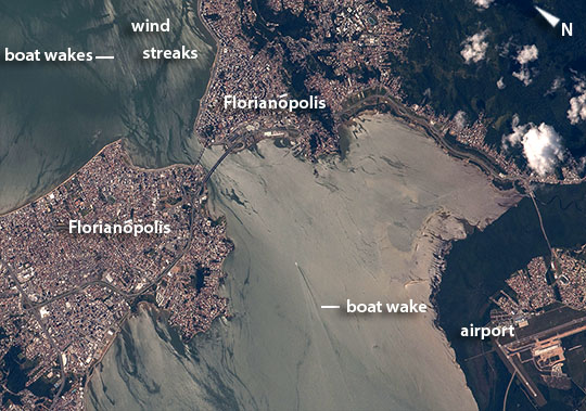 |
| Florianopolis, southern Brazilian This image was taken as astronauts aboard the International Space Station flew over the headlands of the southern Brazilian port city of Florianopolis. The east side (image top right) and west side (image lower left) of the city are joined by bridges that span the 400 m-wide narrows. The International Airport of Florianopolis appears lower right. This city has one of the highest quality-of-life indices in Brazil. The image is illuminated by partial reflection of the sun---revealing all kinds of detail in the water surface, especially wind streaks (image top left) and boat wakes (image center, image top left). The water surface south of the city is far brighter than the surface to the north, probably because the hills where the city is built protect water surfaces from the wind (wind was from the north on this day), producing calmer water and therefore a brighter reflection. Crews have the sense of the glint point moving across the Earth's surface as fast as they are orbiting the planet. This is an example of the training crews receive in the special effects inherent in near-glint-point images of water bodies. |
| Images: | All Available Images Low-Resolution 111k |
|
| Mission: | ISS043 |
|
| Roll - Frame: | E - 101431 |
|
| Geographical Name: | BRAZIL |
|
| Features: | FLORIANOPOLIS, AIRPORT, SUNGLINT |
|
| Center Lat x Lon: | 27.6S x 48.6W |
|
| Film Exposure: | N=Normal exposure, U=Under exposed, O=Over exposed, F=out of Focus |
|
| Percentage of Cloud Cover-CLDP: | 10 |
|
| Camera:: | N6 |
|
| Camera Tilt: | 23 | LO=Low Oblique, HO=High Oblique, NV=Near Vertical |
| Camera Focal Length: | 800 |
|
| Nadir to Photo Center Direction: | NW | The direction from the nadir to the center point, N=North, S=South, E=East, W=West |
| Stereo?: | Y=Yes there is an adjacent picture of the same area, N=No there isn't |
|
| Orbit Number: | |
|
| Date: | 20150410 | YYYYMMDD |
| Time: | 161901 | GMT HHMMSS |
| Nadir Lat: | 28.6S |
Latitude of suborbital point of spacecraft |
| Nadir Lon: | 47.4W |
Longitude of suborbital point of spacecraft |
| Sun Azimuth: | 333 | Clockwise angle in degrees from north to the sun measured at the nadir point |
| Space Craft Altitude: | 219 | nautical miles |
| Sun Elevation: | 50 | Angle in degrees between the horizon and the sun, measured at the nadir point |
| Land Views: | |
|
| Water Views: | |
|
| Atmosphere Views: | |
|
| Man Made Views: | AIRPORT |
|
| City Views: | |
|
Photo is not associated with any sequences | ||
| NASA Home Page |
JSC Home Page |
JSC Digital Image Collection |
Earth Science & Remote Sensing |
|
This service is provided by the International Space Station program and the JSC Earth Science & Remote Sensing Unit, ARES Division, Exploration Integration Science Directorate.

|