Geographic Region: USA-HAWAII
Feature: HAWAII, MAUI, VOG HAZE
|
Geographic Region: USA-HAWAII Feature: HAWAII, MAUI, VOG HAZE |
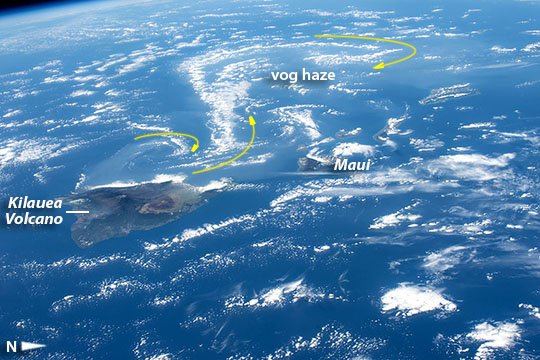 |
| Hawaiian volcanoes, vog and vortices Crews aboard the International Space Station oriented the camera specifically to capture this panorama of Hawaii's Kilauea volcano (image left) with the long swirls of volcanic gases (top half of the image) wafting west from the volcano. Astronauts are trained to take oblique images of hard-to-see atmospheric haze by shooting obliquely to enhance visibility. The gas haze--termed vog, a combination of fog, smog and volcanic--is well known in Hawai'i, and is defined as "a form of air pollution that results when sulfur dioxide and other gases ... emitted by an erupting volcano react with oxygen and moisture in the presence of sunlight". Here the vog haze is transported hundreds of km downwind of the volcano (for scale the Big Island is 137 km, 85 miles, long). In this unusual view the vog forms a series of subtle but distinct alternating swirls (arrows) known as von Karman vortices, a favorite topic for crew photography. Swirls form under specific conditions of high atmospheric pressure and relatively slow wind speeds. They usually develop in clouds downwind of islands, as shown in many astronaut images of cloud patterns. Images of vog haze are captured often by astronauts, but few show the swirl phenomenon. |
| Images: | All Available Images Low-Resolution 109k |
|
| Mission: | ISS042 |
|
| Roll - Frame: | E - 281151 |
|
| Geographical Name: | USA-HAWAII |
|
| Features: | HAWAII, MAUI, VOG HAZE |
|
| Center Lat x Lon: | 20.5N x 156W |
|
| Film Exposure: | N=Normal exposure, U=Under exposed, O=Over exposed, F=out of Focus |
|
| Percentage of Cloud Cover-CLDP: | 50 |
|
| Camera:: | N6 |
|
| Camera Tilt: | HO | LO=Low Oblique, HO=High Oblique, NV=Near Vertical |
| Camera Focal Length: | 78 |
|
| Nadir to Photo Center Direction: | W | The direction from the nadir to the center point, N=North, S=South, E=East, W=West |
| Stereo?: | Y=Yes there is an adjacent picture of the same area, N=No there isn't |
|
| Orbit Number: | |
|
| Date: | 20150218 | YYYYMMDD |
| Time: | 221422 | GMT HHMMSS |
| Nadir Lat: | 21.9N |
Latitude of suborbital point of spacecraft |
| Nadir Lon: | 149.1W |
Longitude of suborbital point of spacecraft |
| Sun Azimuth: | 182 | Clockwise angle in degrees from north to the sun measured at the nadir point |
| Space Craft Altitude: | 214 | nautical miles |
| Sun Elevation: | 57 | Angle in degrees between the horizon and the sun, measured at the nadir point |
| Land Views: | ISLAND, VOLCANO |
|
| Water Views: | |
|
| Atmosphere Views: | FOG, HAZE, SMOG |
|
| Man Made Views: | |
|
| City Views: | |
|
Photo is not associated with any sequences | ||
| NASA Home Page |
JSC Home Page |
JSC Digital Image Collection |
Earth Science & Remote Sensing |
|
This service is provided by the International Space Station program and the JSC Earth Science & Remote Sensing Unit, ARES Division, Exploration Integration Science Directorate.

|