Geographic Region: CHAD
Feature: PAN- L. CHAD, DUST PLUME, BODELE DEPRESSION
|
Geographic Region: CHAD Feature: PAN- L. CHAD, DUST PLUME, BODELE DEPRESSION |
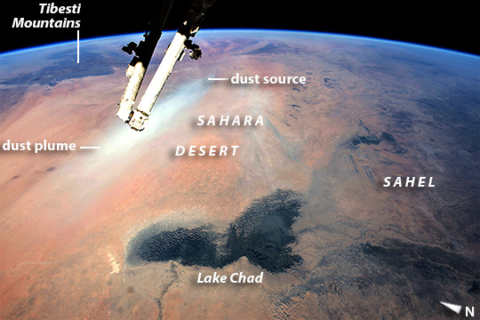 |
| Lake Chad, and Saharan dust plume This east-looking image, taken by astronauts aboard the International Space Station, shows landscapes of the arid Sahara (image left) and the darker vegetation of the wetter semi-arid tropical woodland known as the Sahel (image right). The dark green marshes of Lake Chad stand out in the foreground of this view. Even though it is more than 200 km long, Lake Chad is the small remnant of a vast lake that has repeatedly occupied most of the region in this view in the recent geological past. This lake basin have stretches from the foreground almost 1000 km to the foot of the Tibesti Mountains (image top left). The lowest slopes of the Tibesti show the remnants of great deltas. The image also captures an active dust plume--partly obscured by the so-called Canada Arm of the Space Station. The dust rises from the white mud flats of the ancient lake bed (image top left). Lofted into the atmosphere by northeasterly winds, dust from this basin often reaches the Atlantic Ocean, thousands of km to the west. Occasionally this dust is even carried by weather systems as far as the Americas. |
| Images: | All Available Images Low-Resolution 115k |
|
| Mission: | ISS042 |
|
| Roll - Frame: | E - 244403 |
|
| Geographical Name: | CHAD |
|
| Features: | PAN- L. CHAD, DUST PLUME, BODELE DEPRESSION |
|
| Center Lat x Lon: | 14.0N x 16.0E |
|
| Film Exposure: | N=Normal exposure, U=Under exposed, O=Over exposed, F=out of Focus |
|
| Percentage of Cloud Cover-CLDP: | 10 |
|
| Camera:: | N6 |
|
| Camera Tilt: | HO | LO=Low Oblique, HO=High Oblique, NV=Near Vertical |
| Camera Focal Length: | 32 |
|
| Nadir to Photo Center Direction: | NE | The direction from the nadir to the center point, N=North, S=South, E=East, W=West |
| Stereo?: | Y=Yes there is an adjacent picture of the same area, N=No there isn't |
|
| Orbit Number: | |
|
| Date: | 20150212 | YYYYMMDD |
| Time: | 132753 | GMT HHMMSS |
| Nadir Lat: | 10.6N |
Latitude of suborbital point of spacecraft |
| Nadir Lon: | 10.7E |
Longitude of suborbital point of spacecraft |
| Sun Azimuth: | 231 | Clockwise angle in degrees from north to the sun measured at the nadir point |
| Space Craft Altitude: | 215 | nautical miles |
| Sun Elevation: | 52 | Angle in degrees between the horizon and the sun, measured at the nadir point |
| Land Views: | BASIN |
|
| Water Views: | LAKE |
|
| Atmosphere Views: | DUST, PLUME |
|
| Man Made Views: | |
|
| City Views: | |
|
Photo is not associated with any sequences | ||
| NASA Home Page |
JSC Home Page |
JSC Digital Image Collection |
Earth Science & Remote Sensing |
|
This service is provided by the International Space Station program and the JSC Earth Science & Remote Sensing Unit, ARES Division, Exploration Integration Science Directorate.

|